
My Monday walk this week starts off as one I did back in early May just after the weather first became really nice. I decided to take the dogs for a walk round the Jumbles Reservoir and had two choices – walk all the way from home and back, which was quite a long way, or take the easy way out and drive part of the way there. I chose the first option, and the first part of my walk followed the same route as last week’s walk (although I actually did that one after this one) but when I got to the Bank Top community garden I continued past it and eventually turned left down a steep cobbled lane to a small area which was once known as Ashworth Bottoms.
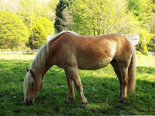
Back in the 1990s I worked down there at a private stables owned by a local businessman – he had three show jumping horses which his daughter rode and I looked after them for the best part of ten years until he sold the big house, stables and land and moved away; I loved that job so I was really sad when it came to an end. The new owners didn’t have any horses at the time and they eventually turned part of the stables into a cattery; I don’t know if it still exists but a couple of horses were in evidence when I went past, one in the field close to the end of the drive and another in the field across the lane.


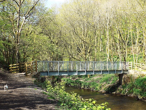
At the bottom of the lane a left turn through a gate took me onto a footpath running through a wooded area and close to the nearby river. It’s usually quite muddy in a few places along there but since the last time I went that way the undergrowth has been cleared, the path widened, drainage put in and the muddy bits are gone. Eventually I came to a bridge over the river and the path through the woods at the far side got quite steep, finally emerging onto the main road running through the Bromley Cross area.


A short distance along the main road and under a railway bridge took me to Shady Lane which turned into Grange Road and would take me to the Jumbles. Grange Road itself was a long and very pleasant semi-rural road with large detached houses on one side and fields on the other, and about halfway along a gate and a footpath on the right took me down into Ousel Nest Meadows, home to several species of wildlife including sparrowhawks, kestrels, herons, foxes and roe deer.


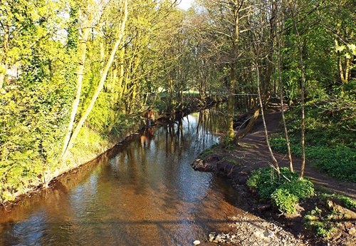
The path went steadily downhill and at the bottom a bridge took me over Bradshaw Brook, then across the far side a winding slope and steps cut into the steep hillside took me up to the car park on the east side of the reservoir. At the far side of the car park was a small cafe and information centre with a few tables and benches outside for people to enjoy the view across the water, and though I was very tempted to get a drink and sit for a while I didn’t.
The path took me through woodland and slightly away from the reservoir, emerging by a concrete bridge over an inlet; as I stopped to look at the view a Springer Spaniel came dashing past me, ran down the bank at the end of the bridge and took a flying leap into the water – its owner, standing further along the bridge, had thrown a ball in for it. I watched for quite a while as time after time the dog retrieved the ball, came back to its owner then waited for the ball to be thrown again before dashing back past me and taking another leap into the water – and I rather think the owner got fed up before the dog did.


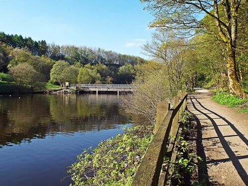
After walking through more woodland the path emerged back by the side of the reservoir and up ahead another concrete bridge crossed the narrowest part. Beyond the bridge was the old quarry, flooded when the reservoir was constructed in the late 1960s and now a popular little spot for fishing. Across the far side of the bridge was a little ‘beach’ of sorts and I stopped there for a few minutes while Sophie and Poppie had a cooling paddle in the water.


From the ‘beach’ the path wound its way through a tree-shaded area, past a row of four stone cottages and a private fishing lake and emerged at a small parking area and a concrete slipway and fishing area at the lakeside; from there a short walk across a bridge over a narrow creek took me to the grounds of the Jumbles Sailing Club where many of the covered up yachts were lying on the grass. It was at this point that Sophie, running ahead a little way, disappeared into the undergrowth and found a patch of mud, emerging with four disgustingly black legs. If only she had found the mud before she had the paddle – fortunately it soon dried up and dropped off and she was back to being white again.


Another wooded area where I got glimpses of the water through the trees then the path took me between the wall and high fence bordering the grounds of a private house and a block of stables and I finally came out at the very bottom end of Grange Road, eventually passing the gate and path to Ousel Nest Meadows. Where Grange Road turned back into Shady Lane was Bromley Cross station with its level crossing out onto the nearby main road so as I like to make my walks circular if I can I went that way instead of going back the way I’d gone. Because of work on the main line at Bolton station there were no trains passing through at weekends so I was in no danger of being mangled while I stood on the track to take a couple of photos.


The next part of my walk took me from the station, past Turton High School and through the main part of Bromley Cross village before I turned off the main road and went past a recreation field and down a flight of wide and shallow steps known as Little Brow. At the bottom of the hill a footbridge next to a road bridge took me over another section of Eagley Brook then a steep cobbled lane known as Eagley Brow eventually led me to the main road through the Astley Bridge area. From there it was a simple matter to zig-zag through the streets until I got home and when I checked the time I realised I’d been out for over three hours – no wonder we were all ready for a good drink and a rest!


I love the name Jumbles. 😁
Typical of white dogs to get muddy. Heehee. 😊
I don’t think I could cope with a white dog. Lol. With black ones mud tends to be ‘ out of sight, out of mind’ , until they shake it all over the house. :b
We were up at Haweswater Reservoir yesterday. X
LikeLike
Surprisingly the dogs do tend to stay white and I very rarely need to give them a bath. Poppie doesn’t really get dirty as she’s on the lead all the time, and if Sophie gets muddy it seems to dry and disappear in a short space of time.
I’ve never been to Haweswater so I look forward to seeing some photos on your blog 🙂
LikeLike
🙂
I am sure I will get posting soon. X
LikeLike
Ok, I’ve earned my morning cuppa now. 🙂 🙂 Thanks, Eunice!
LikeLike
I hope you’re suitably refreshed Jo 🙂 🙂
Several years ago my then partner, who was a landscape gardener, worked at three of the big houses down Grange Road and I would often walk from home and round the reservoir then get a ride back with him when he finished work, so this was the first time I’ve ever walked all the way there and back. No wonder the dogs were cream crackered afterwards! 🙂 🙂
LikeLiked by 1 person
Jumbles reservoir, what a cool name 🙂 I can well imagine that being your dream job at the stables shame it had to come to an end. The water level doesn’t look low and I can’t believe last weekend’s rainfall was enough to replenish them as the news reports we see on the TV would have us believe.
I love to watch Springers retrieving a ball from the water, we see it here down by the sea. I see a man quite regularly, looks like he’s training his dog on the beach. All I have to say to Miss muddy paws Sophie, you could have waited to rinse off 🙂 I take it that’s the same cobbled lane you used to ride your bike down at break-neck speed, it’s a lovely place.
LikeLike
The name Jumbles apparently appeared during the 19th century as a variation of ‘dumbles’ which was a northern term for a ravine-like valley with wooded sides where a fast-flowing stream would tumble down – Bradshaw Brook flows into and out of the reservoir and the land at each end is just as described.
I was really surprised that the reservoir is still so full – compared to when I took the photos in May the water level yesterday was only slightly lower. I remember 15 or 20 years ago the reservoir dried up and my partner and I walked along the bottom of it – in fact we went there twice with the dogs, the first time we were with his brother and sister-in-law and Louise fell into the stream running through the bottom of the old quarry – a stream you can only see when the reservoir is dry. Strangely though I can’t find any reference or photos of it at that time 😦
Yes, that’s the same cobbled lane I would ride my bike down as a teenager, and apart from the concrete strip where it was dug up for pipes to be laid years ago it’s never changed in all that time.
LikeLike
Wonderful photos and seems like you have walked quite much of a distance. The woods, the cross station look so very tempting for a visit.
LikeLike
To walk round the reservoir from Ousel Nest Meadows is just over two miles, so with the distance from home and back again I estimate I walked about six-and-a-half miles. The wooded areas round the lake are lovely in spring and early summer – it’s a great place for a good walk without going too far from home 🙂
LikeLike
I did enjoy this walk, thank you.
LikeLike
Glad you liked it, it’s a lovely walk round the reservoir and one I do often in good weather although I usually drive part of the way 🙂
LikeLike
I am catching up on your posts backwards so it is a refreshing delight to enjoy this walk with you after seeing the photos of fire devastation up on the moor. You do have some stunning countryside around you, hope the girls recovered OK 🙂
LikeLike
I’m lucky enough to live on the northern outskirts of the town Jayne with so much lovely countryside on the doorstep – the south side of town is more ‘industrial’ so not much countryside there at all. Just a ten minute walk from home in three directions and I can be surrounded by fields and woodlands – and no matter how many times I go to a particular place I never get tired of it. The dogs were fine after a good rest and more than ready to go out again by bedtime 🙂
LikeLike