
A few days after the huge Winter Hill fire was officially declared to be completely out and the moorland was reopened to the public I found out about a ‘hidden’ reservoir high up on Smithills Moor which is part of the lower southern slopes of Winter Hill and not far from home, so never having been to that particular part of the moorland before I was itching to explore. However, since the day after my fire station visit three weeks ago the local weather has been cloudy and grey with several days of rain, which wasn’t good for moorland walking or photo taking, but last Friday morning it was very warm with a cloudless blue sky and lots of sunshine so I grabbed the opportunity, threw the dogs and the camera in the van (not literally!) and off I went.
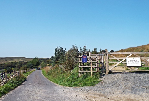
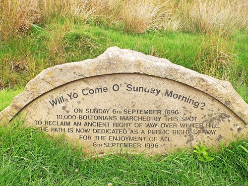
The reservoir I wanted to find was called Dean Mills, it had been constructed in the late 18th century to provide water power via a waterfall and a series of sluices to a spinning mill of the same name at Barrow Bridge village down in the valley. Someone who lives local to me had suggested (via a home brew forum!) the best way to get to it, which involved driving for about a mile along a narrow lane and taking a footpath off it – I found the start of the path with no problem and was just about able to park the van near the gate on a narrow strip of land at the side of the lane. A sign on the gate told me that this was now part of the Woodland Trust’s Smithills Estate, and just at the other side of the gate was a large carved memorial stone erected in 1996 on the centenary of the Winter Hill Mass Trespass.
In August 1896 local landowner Colonel Richard Ainsworth planned to use the whole area of open moorland for grouse shooting and decided that the lane known as Coal Pit Road was private so he put a gate across the lower end to prevent public access, but two local men who were against the idea decided to organise a mass trespass to reclaim the ancient ‘historical right of way’. On September 6th that year around 1,000 people assembled just to the north of Bolton town centre and set off on the seven mile walk through the Halliwell and Smithills areas and over the top of Winter Hill via the disputed track – as they headed towards Coal Pit Road many more joined the march and by the time the gate was reached there were 10,000 people walking, led by a brass band. Although Colonel Ainsworth’s men and members of the local constabulary made a stand the gate was attacked and demolished and the protesters rushed through onto the disputed land, eventually forming a stately procession over the moor to the summit.
Over the coming three weekends more marches were held but eventually Ainsworth succeeded in getting writs issued to the leaders and the marches stopped while the court case was held. Unfortunately for the leaders the Colonel won the case and proceeded to take it out on them by claiming damages and court fees which bankrupted them – Smithills Moor was finally closed off and the Colonel was able to indulge his love of grouse shooting. By 1938 the moor had passed into the possession of the local council and on the back of the smaller but more famous 1932 mass trespass of Kinder Scout in the Peak District the path was reopened to the public, though it wasn’t until June 1996 that it was finally declared to be an official Right of Way. The first words on the memorial stone are from a short poem written by one of the locals at the time of the mass trespass.
“Will Yo’ come O Sunday Mornin’ Fo a Walk O’er Winter Hill?
Ten thousand went last Sunday But there’s room for thousands still!
O the moors are rare and bonny An’ the heather’s sweet and fine
An’ the road across the hilltops is the public’s — yours and mine.’
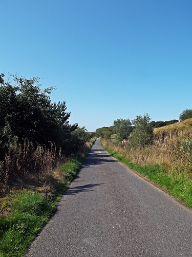
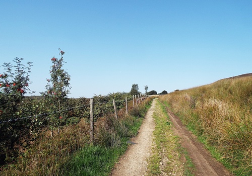
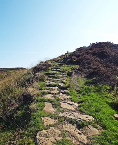
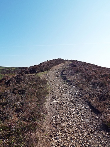
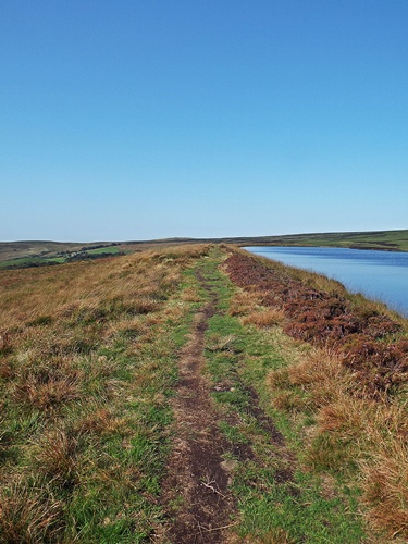
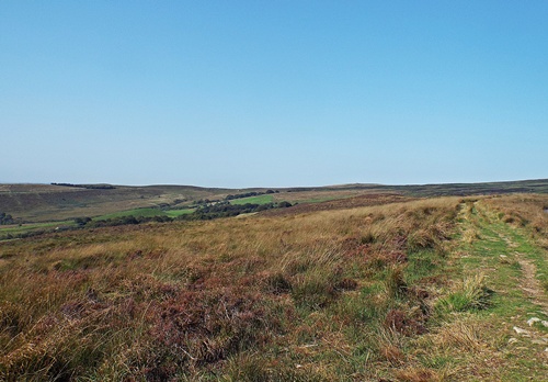
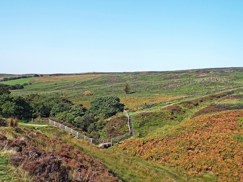
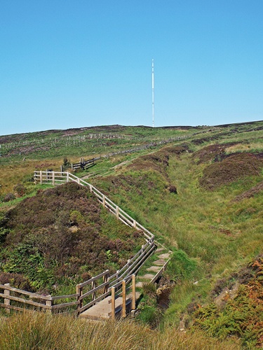
A couple of hundred yards from the gate the path curved round to the right for a short distance then crossed a stream via some steps and a short boardwalk and continued uphill across the moor, but my route took me up a small but very steep hill on the right via some very rough and uneven rocky steps. At the top of the hill I was faced with a second steep hill and a rough path up it, though once I got to the top the land levelled out and the path became more grassy. It didn’t take long to reach the reservoir – looking at Google Maps satellite view I’d got the impression it was quite a distance from the gate but it had only taken twelve minutes to walk up there so it was no distance at all.
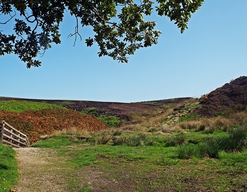
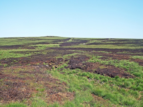
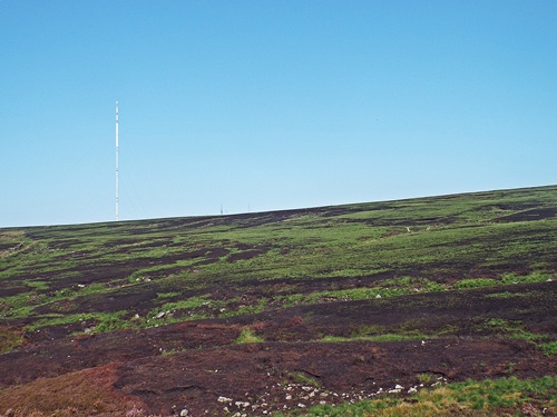
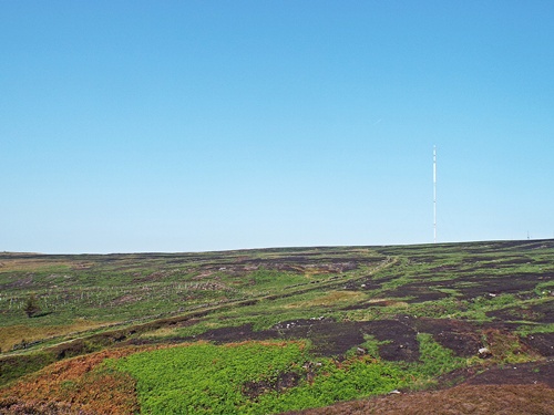
The reservoir itself is situated in one of the most exposed and wind swept parts of the moors and is nothing special to look at, but being so high up it gave far reaching views to Manchester and beyond although those views were a little hazy in the warm sunshine. Looking round at the immediate area there was much evidence of the recent fire – huge areas of burnt and blackened moorland, patches of heather which should have been blooming but which were a charred and blackened mess, and over the far side of the reservoir I could see where the fire had burned right down to the water’s edge. Apart from the occasional bleat of a sheep in the distance there was no sound anywhere, and with no other humans around I had the place completely to myself.
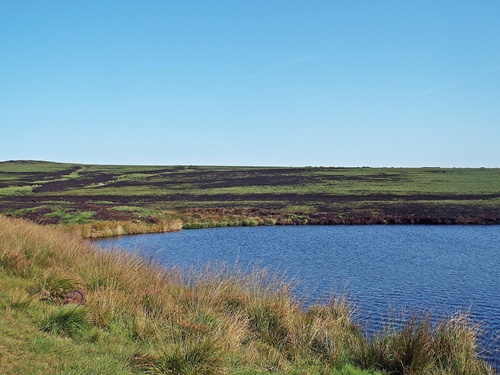
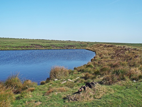
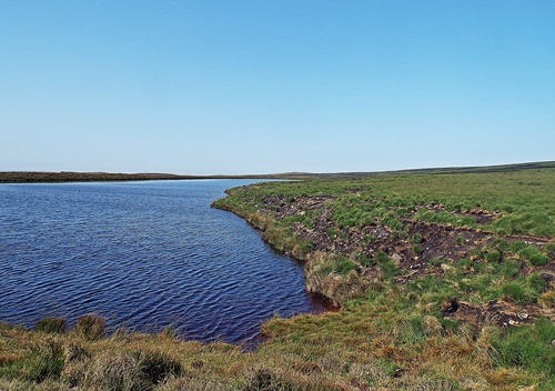
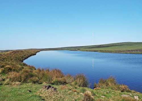
Unfortunately I was prevented from walking all the way round the reservoir by a stream and some very boggy land at each end so once I’d got the photos I wanted I retraced my steps along the south side; the views over the nearby countryside and farm land were good and in the distance to the west I could see the small hill with the three cairns of the Two Lads on another part of the moor. Away from the reservoir the patches of burnt land encroached closer to the path and in several places the path itself had been burnt, evidence that the reservoir had at least stopped some of the fire from spreading even further.
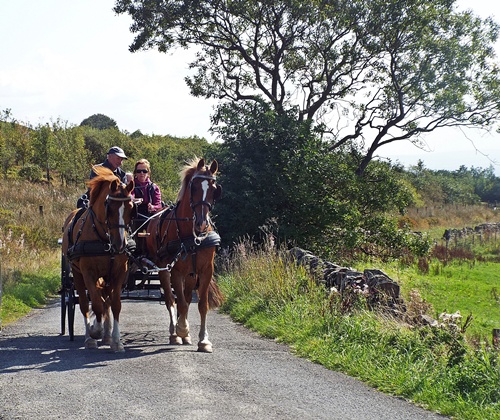
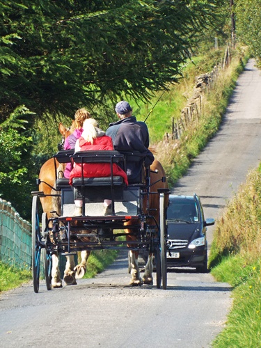
After safely negotiating the rough steps back down the steep hill I made my way back to the van and I’d just got through the gate onto the lane when a carriage carrying three people and pulled by two almost identical ponies appeared round the bend in front of me – it had just got past me when it came face-to-face with a car coming the other way. The car driver must have had to reverse quite a long way back to allow the carriage to pass as I’d put the dogs back in the van, reversed and done a difficult 4-point turn in the narrow lane, avoiding the hidden ditch on either side, and got halfway back to the main road before the car appeared behind me.

I love the poem, though its a shame the locals didn’t win the case. 😦 A pleasant walk on a lovely Summers day. X
LikeLike
I wouldn’t have thought so many people lived in this town back then but obviously they did. It was a shame they didn’t win, but even these days it’s an unfortunate fact that those with plenty of money will always get the upper hand 😦 At least the moors were eventually reopened to the public, and there’s been no grouse shooting up there for many many years. In spite of the two steep hills I had to climb the walk was an easy one, and with a warm and gentle breeze blowing across the reservoir it was really pleasant 🙂
LikeLiked by 1 person
It was a beautiful morning for your walk. I don’t blame the locals for trying to reclaim the right of way and with such huge support but as always the gentry with money win 😦 The route you took is certainly steep and rocky! How lovely to see the horses and carriage on the lane, I’m glad they had the right of way 🙂
LikeLike
It was a glorious morning and I was glad later that I’d taken advantage of it. The reservoir can’t be seen from anywhere down below or from most other parts of the moor so in a way it really is hidden – one of those places you would only know was there if someone else told you about it or you discovered it by accident while walking in that area. The route was certainly steep and rocky in a couple of places but the only other alternative was to go up to the mast via another route and walk down from there, which is a much longer way. It was lovely seeing the carriage and ponies coming towards me and quite unexpected – I was lucky to get the shot too as they were moving at a good pace.
LikeLike
Morning, Eunice! 🙂 🙂 I just barely had time to slot your walk in, before I’d even had a proper chance to read it. The home brew forum made me smile. The landowner not so much. Despite all that effort! Many thanks for sharing, hon. Have a great week!
LikeLike
You too Jo 🙂 I found the home brew forum through searching for details about the reservoir, an excerpt from a forum post came up and it turned out that the guy who wrote it lives just up the road from me and had recently been to the reservoir himself, so even though I neither drink nor brew my own beer I joined the forum just to ask him how to get there! The internet can be so wonderful 🙂 🙂
LikeLike
Those sorts of stories make my blood boil! Nice walk though.
LikeLike
It was a lovely walk and the weather was perfect. I was only out for an hour and a half including driving from home and back so it’s a walk which is short enough to do when I don’t have a lot of time 🙂
LikeLike
That was very interesting. I had no idea wild fires had been burning so savagely across the moors. Surely that doesn’t happen very often.
LikeLike
Fortunately it doesn’t happen often – I think the last time that part of the moorland was on fire was about 25 years ago and it wasn’t very much compared to this recent one. The long spell of unusually hot dry weather didn’t help this one as the land was so dry but it was actually started by arsonists – two separate fires which merged into one and covered a total of over five square miles of moorland. Fire crews came from other parts of the country miles away to help out and there were 32 fire engines here at one point – you can read more about it in these posts with photos – https://mousehouselife.wordpress.com/2018/07/06/the-battle-continues/
This is an area close to home and I’m familiar with many parts of it through walking the dogs so to see the devastation this fire caused is a real eye opener. Hopefully another fire on this scale won’t ever happen again but unfortunately there’s no accounting for the stupidity of mindless people who cause them 😦
LikeLike
What a wonderful walk and a fascinating piece of English history. Guess it’s unsurprising the courts at that time sided with the landowner.
So glad they finally controlled the fires. The pictures I saw were terrifying. Hope the land recovers quickly and that the landowners allow vegetation to grow as it should, thereby make the land more fire resistant in the future.
LikeLike
It was a lovely walk, and I didn’t know about the history until I researched the memorial stone by the gate. I never really liked history when I was at school but local stuff fascinates me. I did the walk again a couple of evenings ago, the conditions were just right for some sunset photography but I’d just got there when my camera batteries died! 😦 At least the dogs had a good walk so they weren’t complaining 🙂
LikeLike
What a lovely walk! It looks so pretty and peaceful! I am glad the fires were put out completely.
Unfortunately, we have a lot of fires out west where we get smoked covered over 2000 miles away.
xx Mya
LikeLike
The moorland fire lasted for 42 days before it was officially declared to be out completely. A lot of land was decimated and various wildlife species were affected but three years on there’s very little sign of the fire now. The lower slopes of the moorland are only a mile and a half up the road from home so I’ve done this walk a few times since I wrote this post – it’s a nice one to do when I don’t have a lot of time.
LikeLike