
Back in January this year I watched the second series of a crime drama shot in and around Morecambe. Most of the locations I instantly recognised from previous visits but there was a house featured in a place which I felt I knew even though I also knew I’d never been there. Some logical thought and a study of Google maps and street view eventually showed me where it was so the Saturday morning of the August bank holiday found me driving along Morecambe promenade and the coast road to arrive in Hest Bank just a couple of miles northwards.
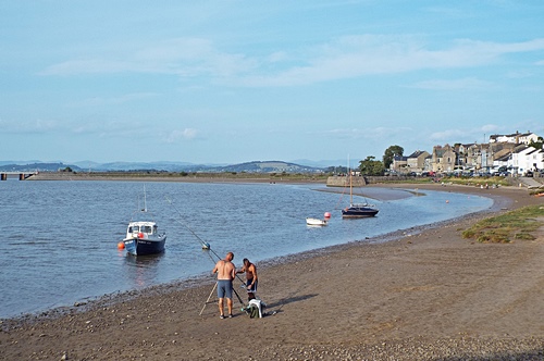
The road to the shore was crossed by the west coast main train line and the barriers were down when I arrived so I had to wait a few minutes for the trains to pass. Just beyond the level crossing was a parking area and a small cafe, with a long and pleasant green overlooking the bay and a few more small parking areas set at intervals just off the tarmac lane. With just a couple of large semis and a very small residential static caravan site there was nothing there but it was a nice enough little place which seemed to be popular with walkers with or without dogs, while the vast expanse of sands provided good cantering for a couple of horse riders.
Walking northwards I soon found the house I’d seen in the tv series; the lane turned into a gravel track there which ended in another small parking area and a grassy foreshore above the shingle beach. I would really have liked to walk on a bit further but I could see quite a few people in the distance with several off-lead dogs, something which Snowy doesn’t like, so I turned round there and headed back the other way. Back at the van I got chatting to a couple about to set off on a bike ride along the Lancaster Canal; it seemed it was only a short distance away so I decided to leave the van where it was and go check it out.


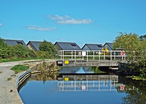
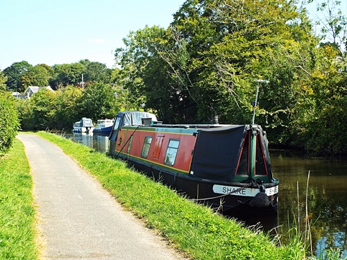
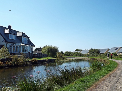
I found the canal quite easily and my walk northwards started from Bridge 118, built in 1797, but if I’d been expecting to pass through some nice countryside I was destined to be disappointed as the canal was lined on both sides with houses and bungalows. Many of the properties on the far side had large attractive gardens reaching down to the canal side while those on the towpath side were set just below the canal bank. Long strips of well mown grass separated the boundary walls and hedges from the towpath and I got occasional views over the rooftops to the bay.
Not knowing how far I would have to go to find some countryside I gave up at Bridge 122 and set off back to where I started; I had other places to go to so I didn’t want to spend too long looking for something which could possibly still be miles away. Bridge 120 was a ground-level swing bridge which seemed to provide access to just one house set on its own and not far away was a quirky looking cottage with a not-very-straight roof and an overgrown garden. I couldn’t tell if it was lived in or empty but it intrigued me enough to take a quick photo.


My next port of call was Silverdale but knowing how to get there and actually getting there were two completely different things. What should have been a relatively easy drive from Carnforth turned into an epic all-round-the-houses, miles-out-of-my-way journey round unknown country lanes due to a closed road and diversion at a crucial point, but I got there in the end.
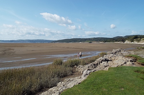
Now I remember going to Silverdale as part of a coach trip with my parents when I was about 9 or 10 years old and though I don’t recall going to the village itself I do remember being totally unimpressed with the coast part of it as there was absolutely nothing there, so I was hoping that after all these years it might have changed a little. It hadn’t – there was still the same rough parking area, the same row of cottages set back behind a high concrete sea wall, the same ankle-twisting rocky shoreline and vast expanse of sand. Yes, the view across the bay was good but other than that there was nothing – in less than ten minutes I had all the photos I wanted and I was back in the van.


Next on the list were Jack Scout nature reserve and Jenny Brown’s Point, a relatively short drive from the village and neither of which I’d been to before. Unfortunately I couldn’t get remotely close to either of them in the van; about halfway there I was met by the second Road Closed sign of the day so I had to find a convenient place to park on a nearby lane and walk from there.
Jack Scout is an area of low limestone cliff owned by the National Trust, with its name thought to have come from old English or Norse meaning a high point where oak trees grow. Well known for its wildlife and extensive views over Morecambe Bay the area features a partially restored 18th century lime kiln and the Giant’s Seat, a huge limestone bench. Unfortunately I didn’t get to see either of these as a notice on the gate leading into the grassland warned of cows in the area and sure enough I could see several of them mooching about among the trees and shrubs. Not wanting to put myself and the dogs at risk I decided not to go there so another few minutes walking finally got me to Jenny Brown’s Point where a couple of benches set down off the lane gave great views over the channels flowing into the bay.


No one really knows how Jenny Brown’s Point got its name. One story says she was a young maiden hopelessly scanning the distant horizon for the return of her lover, another that she was a nanny, cut off and drowned by the incoming tide while trying to rescue the two children in her care, though the more believable theory stems from the 1660s when a mother and daughter, both named Jennet Brown, lived at Dikehouse, the farm at the Point. The area has also been known as Brown’s Point (1812), Silverdale Point (1818) and Lindeth Point (1828) though Jenny Brown’s Point was in use on an 1829 estate plan and has been used by the Ordnance Survey from 1848.
One story which is certainly true is the tragic tale of the Matchless, a converted fishing boat used for taking holidaymakers on trips across Morecambe Bay during the summer months. On September 3rd 1894, carrying 33 passengers and just one skipper/crewman, the boat left Morecambe to sail to Grange-over-Sands but just off Jenny Brown’s Point it was hit by an unexpectedly sudden strong gust of wind. Within seconds it capsized, throwing people into the water where many became fatally tangled and trapped in the sails and ropes. Although other nearby pleasure boats came to the rescue only eight passengers and the skipper were saved; 25 holidaymakers including five children, the youngest only 2 years old, all perished.

A few hundred yards away from the benches the lane ended at the 18th century Brown’s Cottages where huge slabs of limestone looking almost like a slipway led down to the waterside. Nearby were the remains of what would once have been a small quay and part of a broken bridge which would have crossed the channel known as Quicksand Pool.


Just beyond the cottages was an old chimney, now Grade ll listed and believed to be the remains of a short-lived copper mining and smelting project set up in the 1780s by Robert Gibson, Lord of the Manor of Yealand. He wrongly assumed that he had the right to mine for copper on nearby land owned by the Townleys of Leighton Hall and the copper was processed in a furnace at Jenny Brown’s Point, but after several lawsuits the whole operation was abandoned in 1788; Gibson died three years later in 1791.

From Jenny Brown’s Point I walked back along the lane to the van then drove the four-and-a-bit miles round to Arnside. Normally I wouldn’t like to drive into Arnside on a bank holiday as it would be extremely busy and parking wouldn’t be easy but it was gone 5pm by the time I got there and many day visitors had already left so I was able to find a parking space near the far end of the promenade.
Arnside village is situated on the West Coast main railway line in an Area of Outstanding Natural Beauty. At one time it was actually a working port but building the viaduct across the Kent estuary in 1857 caused it to silt up, making the port no longer viable. The viaduct itself is 552 yards long with 50 piers; it was rebuilt in 1915 and is a very prominent feature of the village, being more or less the first thing to be seen when coming into Arnside past the railway station.


The pier was constructed by the Ulverston and Lancaster Railway Company in 1860, replacing an earlier wooden structure and also providing a wharf for ships after the building of the viaduct prevented them from reaching the inland port of Milnthorpe. In 1934 a storm destroyed the end section of the pier which was subsequently rebuilt by the London, Midland and Scottish Railway Company, then in 1964 Arnside Parish Council bought the pier for £100. Following a storm on the night of January 31st 1983 it was rebuilt by the Parish Council after the cost was raised by public subscription and grants, and it was officially re-opened on April 12th 1984.


Walking along the promenade I heard the sound of singing coming from upstairs in the sailing club building which was once the Customs House. A board outside said the place was open so for curiosity I popped inside; a steep wooden staircase led up from the corner of a very simply furnished room and from up above came the sound of laughter and the chink of glasses. There was nothing to say if this was a public event or a private one but I don’t like sea shanties anyway so I didn’t bother finding out.


My walk took me to the end of the pretty promenade gardens before I turned round and headed back to the van, with a quick detour up Pier Lane on the way. It was well after 6pm by then, the lane was in shade and the few small shops were closed but as I’d never been up there before it was worth a quick look.


Wow, that was quite some day out! Despite it being August Bank Holiday it looked like you found some fairly quiet places.
The houses next to the canal have themselves a rather lovely location, if I did not live here I think I’d quite happily settle there 😊
LikeLike
Who wouldn’t want to live by a canal in a lovely location 🙂 The walk was really lovely in spite of there being houses on both sides. Looking at Google maps I would have had to go just past one more bridge to find countryside, or if I’d gone south from where I started I would have found it fairly quickly. Something to think about for another time maybe 🙂 Quite coincidentally, I found out yesterday that P’s brother and sister-in-law were moored up by Bridge 115 on the same day so if I HAD gone south I would probably have seen them 🙂
LikeLike
That certainly was a long and interesting day out for you. You took some lovely photographs even though your trip didn’t go exactly to plan. You do have to wonder how long the cars on Silverdale beach planned to stay with not much there. I think sea shanties became popular again during the pandemic as I heard quite a few on the TV for some reason, I think I would have listened for a while but not gone up the stairs to join in with them. I always love a photo of Poppie and Snowy enjoying their day out too.
LikeLike
Silverdale is a popular walking area so maybe some of the cars on the beach would have been there most of the day while their owners were off walking somewhere. I thought by now there may at least have been an ice cream van there, especially with it being the bank holiday, but there was nothing – what you see here really is what you get. I think the dogs enjoyed their day, they were certainly tired out by the time we set off for home 🙂
LikeLike
I definitely recognise some of your photographs from my recent trip to Arnside and Silverdale too. I love the photo of Poppie and Snowy on the bench at Jenny Browns Point. I took a photo for someone of them and their dog on that very bench a couple of weeks ago! X
LikeLike
Snowy escaped from her harness just after I took that photo of them but fortunately she came to me and didn’t wander off. I’ve adjusted it now so hopefully she won’t do it again 🙂
LikeLiked by 1 person
Phew! Little tinker. X
LikeLike
I got the mini size but it was still too big for her. I’ve adjusted the chest strap three times now so hopefully she won’t get out of it again. It’s one of those supposedly ‘no pull’ ones but does it work? – no! 🙂
LikeLike
They never do, lol. Hugo always figured them out pretty quickly so we don’t bother now. He still pulls! X
LikeLike
Nice write up.
I always get lost in those lanes between Silverdale and Arnside.
LikeLike
Silverdale to Arnside is a reasonably straightforward drive but getting to Silverdale with that diversion was a bit of a mare, I thought I was never going to get there.
LikeLiked by 1 person
When I first read the title I thought that must have been quite a long walk 😉
I don’t think I’ve ever spent any time in Silverdale (possibly because there isn’t much there) but the surrounding area is pretty and there are some lovely walks nearby,
I only very recently remarked that I haven’t seen any hot air balloons this year. There don’t seem to be as many around as there used to be. X
LikeLike
Ha ha 🙂 Hest Bank to Arnside is only just over 11 miles but then I’d have to walk back again – I’m good but not THAT good 🙂 The area around Silverdale is lovely but I won’t be in a rush to go back to Silverdale itself. I do like Arnside though and some day I want to walk up to Arnside Knott.
LikeLike
A bit of an all-round adventure, Eunice! Love the canalside parts.
Just wanted to let you know I’m back- the same but different, and mostly focused on my English trip for the next week or three.
https://stillrestlessjo310242783.wordpress.com/2021/09/13/jos-monday-walk-the-canal-beat/
LikeLike
Some of my nicest walks have been along canals Jo, I love them. Sorry for the delayed reply, however I’m back to reality now from my Cumbria camping trip. Thanks for the link to your new blog, I’m looking forward to reading more as it progresses 🙂
LikeLike
You’ve brought back a few memories here Eunice. I don’t know Morecombe Bay intimately, but I do like it. That boat tragedy was terrible, and who can forget those poor cockle pickers who got caught by the tide? I followed your trip on Google maps which always makes it more interesting I reckon. Some smashing photos again too.
LikeLike
I often look at Google maps if I’ve seen something of interest on tv or someone elses’s blog, it usually tells me if a place is worth going to or not. I would probably never have thought of ever going to Hest Bank if I hadn’t seen that house on the tv programme and tracked it down via Google maps. And if I hadn’t gone there I wouldn’t have had the bonus of a nice canal walk 🙂
LikeLiked by 1 person
Very true 🙂
LikeLike