In contrast to the glorious sunshine and blue sky of the previous day the morning was cloudy, grey and miserable with the wind still blowing an absolute hooley. The tent was still standing, albeit a bit out of shape on the side where the wind hit it, but not wanting to go out and risk coming back to find that another disaster had occurred I spent quite some time re-pegging and double-pegging all the guy lines and anchor points, which were checked and re-checked during the course of the morning. By 1.30pm though I’d had enough of being ‘stuck indoors’ but with so much grey cloud around it wasn’t worth going to the next place I’d planned to visit so I decided to have a mooch along Rhyl promenade, somewhere I hadn’t yet been.
Parking at the harbour I crossed the modern footbridge over the river onto a short stretch of main road and from there onto the pedestrianised sea front where I walked along until I ran out of buildings then headed back along the main promenade, taking snaps of anything which looked marginally interesting including the colourful childrens’ fairground rides, although I missed out the clock tower – apparently erected in 1948 it was in the middle of a small roundabout and was square, plain, and intensely ugly.
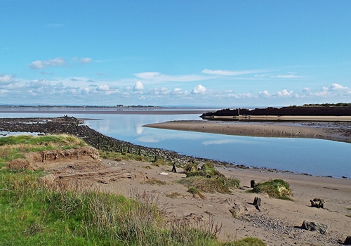
An empty beach on a dull day – looking towards the harbourShell mosaic set into a wall
A lonely duck on a small pondWall art at the Kite Surf Cafe
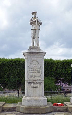
War memorial garden and cenotaph
Decorated stone gate posts at St. David’s residential home
Colourful map on the wall of the indoor water parkA fearsome looking creature above an amusement place
By the time I’d got back to the van I was feeling more than a little peckish so decided to treat myself to a meal in The Harbour, one of the Hungry Horse chain of pub/restaurants where I knew I could get some decent food. I just fancied a chicken tikka masala but sod’s law said that was one of the three things on the menu which they hadn’t got so I settled for steak and ale pie instead. I was only in there for an hour but when I came out I was surprised to find that the grey clouds had cleared away and the sunshine and blue sky were back, although by then it was too late really to go anywhere else and I didn’t feel like repeating the long promenade walk just to get some better photos.
Deciding to go and see Yasmine, the horse which Eileen often visits, I popped across the road and bought a small bag of carrots from Aldi as I didn’t want to go without taking a treat for her. On the way there I noticed that the friendly neighbourhood giraffe had swapped his jubilee crown for a sunshade so of course I had to stop to get another couple of photos of him.
Yasmine was in the far corner of her field when I got there but she ambled over slowly when I called her. She’s a very sweet horse and loves her treats but I only gave her three of the carrots, saving the rest for another couple of visits, then after making a fuss of her I set off back to the camp site to chill out for the rest of the day.
My walk along Rhyl promenade had been what could loosely be called ‘interesting’ – never having been there before it was good to see what the place had to offer but it was nothing to write home about, though I don’t think the dull grey day showed it at its best. Maybe it would look much better in the sunshine so who knows? – I might just do that walk again on a much brighter day in the future.
I made sure I had breakfast in good time that morning as I didn’t want to be in the middle of a plate of toast and marmalade when the second RAC guy arrived with my new battery. This second visit was supposed to be before 10am, however that time came and went and there was no sign of an orange van anywhere. Okay, depending on where the guy was coming from he could have got stuck in traffic somewhere so I didn’t mind waiting a while longer but when it had gone past mid day and there was still no orange van I was getting more than a little fed up.
With no update from the RAC, either by text or phone call, I decided to try to contact them myself but that was an epic failure. Yet again the automated system wouldn’t recognise some of my details (which aren’t at all complicated) and trying to get through on the sales line resulted in me being cut off twice before I even got to speak to someone. I was getting nowhere fast, the day was creeping on and I’d achieved nothing so I decided to take matters into my own hands.
Luckily I’d discovered by accident that I could get internet access on the site – it wasn’t the best but it was adequate, especially if I went to the end of the site nearest the main house, so I googled for car accessory shops in the area and found one not far away in Abergele. Fortunately the van started okay with the current battery so a quick phone call ascertained that the shop had a battery in stock the same make and power though they wouldn’t put it on the van for me, however I had a word with one of the farm guys and he said he would do it.
It looked like I would finally get things sorted out without the help of the RAC but just before I left the site I realised I couldn’t find my bank card. It was nowhere – not in my bag, my holdall, jacket pockets or the glove box, it had completely disappeared although I couldn’t think how or where I could have lost it. Luckily I had just enough cash to pay for the new battery so I went to get that then called at Eileen’s on my way back to the site to ask if she knew where there was a branch of my building society. She and her hubby came up trumps and said there was one in Colwyn Bay, also she found the phone number to report my card as being lost, which I did straight away, then I went back to the site and the farm guy put the new battery on the van for me. Finally, and with no thanks to the RAC, I was properly mobile in the knowledge that the van wouldn’t give up the ghost again, and not wanting to waste any more of what had turned out to be a lovely afternoon I drove the few miles up to the Marble Church situated just off the A55 at Bodelwyddan.
The Marble Church, or to give its proper name St. Margaret’s, was built in the mid 19th century in the Decorated Gothic style and contains fourteen different varieties of marble. According to the church website it was supposed to be open to visitors daily between 10am and 4pm but when I got there I found it was very firmly closed, so I could do nothing other than take a few photos from the outside and hope it would be open the following day.
The marble church (St. Margaret’s) BodelwyddanCanadian war graves
By the time I’d finished wandering round it had gone 4pm and I didn’t really feel like going anywhere else at that time so I just went back to the camp site and settled in for the rest of the day. It was 7.15 that evening when I got a phone call from an RAC guy to say that he would be with me in twenty minutes with a new battery; all day without an update from anyone and he rings me at this time?? He did give me an excuse about having the wrong phone number for me, which I didn’t believe for a minute, so I just politely told him to go back to where he came from and take the battery with him as I’d already sorted it out myself.
The following morning I got an email from the RAC inviting me to fill in a survey about my recent roadside experience so it could be used (quote) ”for the continuous improvement of our service to you, our valued customer”. Filling in the survey on my tablet wouldn’t be the easiest so I decided to wait until I got back home then I would let them have it with both barrells; after the appallingly diabolical service I did receive I certainly didn’t feel very ‘valued’, and needless to say I won’t be renewing my breakdown cover with them when it’s due.
Day 3 arrived with glorious early morning sunshine and after spending the previous day on site I was looking forward to getting out and about but unfortunately the sunshine didn’t last. By the time I’d taken the dogs out and had breakfast grey clouds had rolled in from all sides and the blue sky had vanished, effectively putting paid to my plans. Okay, I could still go out but grey clouds wouldn’t show the planned location at its best so I had to have a rethink.
Eventually I decided on an alternative but actually going there was a different matter, in fact I couldn’t even get the van off my pitch – it was well and truly stuck there. Somehow, and I don’t know how, I’d got a flat battery – it was as if something had drained it overnight but that was impossible as the key hadn’t been left in the ignition and I had the site electric supply for lights and everything else so there was nothing in the van which could have been left on. So I called the RAC – and that’s when my troubles really began.
Trying to actually speak to a living human being was a nightmare – first the automated reporting system wouldn’t recognise my surname, then it wouldn’t recognise my home postcode, then it wouldn’t even recognise my reg number which it previously had recognised. I was getting more frustrated by the minute so in desperation and on the fourth attempt I rang the sales line, finally speaking to someone who took my details and said someone would come out to me. The guy who eventually arrived started the van no problem, checked everything over and said the battery was low on power so it might be advisable to get a new one or I could end up with the same problem in another day or two.
A battery of the size and power I needed wouldn’t be cheap, in fact it was darned expensive and an unforeseen amount I didn’t really want to pay but I didn’t want to risk being stuck again or having to go through the RAC’s stupid automated system a second time so I agreed to have a new one. The guy didn’t have one on his van though so he rang someone else and arranged for a re-attend the following morning to supply and fit a new one, stressing that it must be no later than 10am as I had said I had plans to go out and didn’t wanting to be waiting around on the camp site.
By the time the RAC guy had gone it was too late to really go anywhere and it was still cloudy anyway so I just drove the seven miles to Tesco in Abergele to get some supplies then stopped off at Asda for another couple of things. On the way back to the camp site I passed the friendly neighbourhood giraffe and noticed he was still wearing his Jubilee crown so of course I had to stop and take a couple of photos – regardless of what he’s wearing he makes me smile every time I see him.
With the cloud continuing through the late afternoon and into the evening I spent the rest of the day on the camp site and went to bed that night with fingers metaphorically crossed that once the RAC had fitted a new battery on the van the following morning I would finally be able to go out somewhere, however more unwanted aggravation was to come.
If ever there was a holiday when a catalogue of things conspired against me this one was it, and though I don’t believe in fate or ‘things happening for a reason’ it didn’t bode well for my break when two days before travelling I got a head cold. The weather on the first day was abysmal, it rained steadily from home all the way to North Wales and effectively stopped me from visiting the two places I’d planned to go to en route, though a slight change of plan saw me calling to see Eileen and her hubby that afternoon instead of waiting until the evening and a very pleasant couple of hours was spent in the company of two lovely friends and Tilly the cockapoo.
The rain had stopped by the time I left Eileen’s and went to the camp site but halfway through setting up the tent it started again and by the time I’d got everything sorted out I was ever-so-slightly damp. A change of clothes and a chill out evening followed and by the time I was ready for taking the dogs for their bedtime walk later on it had been fine for a while so thankfully I didn’t get wet again.
The following day was a mixture of sunshine and cloud and not being too fussed about going anywhere I decided to just spend the day on the site, which I had all to myself as there was no-one else there. Prior to the start of the holiday I’d ordered online a couple of large waterproof fleece picnic rugs to use as carpets in the tent, and knowing they would be delivered while I was away I’d asked Eileen if they could be sent to her so I could collect them and put them to use straight away. They weren’t due until the following day but I got a message from Eileen later that morning to say they had already arrived and she and her hubby would bring them over to me later on.
Entertaining guests at my tent isn’t something I would normally do so this was different. It was nice to sit outside in the sunshine and chat over a brew and Tilly was really good – Eileen liked my tent set-up and given the chance I think Tilly would enjoy the camping life. The picnic rugs were much larger and nicer than I expected – I put them down in the tent later on and they looked great so I was really pleased with them.
Photo taken by Eileen
Taken by Eileen
Taken by Eileen
Later, with the new ‘carpet’
From Michael and Laura for my birthday – a bit past their best but still too nice to leave at home
After my guests had gone the rest of the afternoon and evening were spent relaxing with a book and watching a bit of tv, with an earlier than normal bedtime, though as I settled down for the night I had no idea of the frustrating things to come over the next couple of days.
Going home day arrived with more blue sky and glorious sunshine making me wish I could extend my holiday but unfortunately all good things have to end sometime. After a leisurely breakfast I started on the even more leisurely packing up process and eventually left the site at 2.30pm, though as a final part of the holiday I was stopping off somewhere on the way home.
The village of Greystoke, just five miles west of Penrith, was featured in my ”111 Places” book and it sounded interesting enough for me to want to take a look, though when I got there I was disappointed to find that the castle isn’t open to the public. Surrounding a small green with an ancient market cross dating back to the early 1600s the village was a very pleasant mix of old stone cottages and more modern houses, with a small shop-cum-post office, an outdoor swimming pool, St. Andrew’s Parish Church and the Boot & Shoe public house, while on the outskirts were racehorse trainer Nicky Richards’ racing stables, breeders of two Grand National winners in 1978 and 1984 respectively.
Greystoke Castle began life as a timber pele tower built by Llyulph de Greystoke. After the Norman conquest it was replaced in 1069 with a stone built tower then in 1346 King Edward III gave permission for the building to be castellated, resulting in the creation of the castle proper. In the early 16th century the Greystokes married into the wealthy Dacre family and in the 1560s Thomas Howard, the 4th Duke of Norfolk, met and secretly married widow Elizabeth Dacre who had inherited the castle and its land on the death of her husband, 4th Baron Dacre/Baron Greystoke. With Thomas Howard’s three sons marrying Elizabeth’s three daughters the castle and its estate passed into the hands of the Dukes of Norfolk and the subsequent Howard family.
In 1660 the castle was destroyed by Cromwell and lay dormant for a generation, with a small manor house being built on the site from reclaimed stone. The castle was later rebuilt and enlarged in the 1840s to a design by renowned Victorian architect Anthony Salvin and the extensive estate land was converted into a modern farm. In 1868 a disaster occurred when a maid left a lighted candle in a cupboard full of linen, with the resulting fire destroying large parts of the castle. It was then rebuilt by Henry Howard, with Salvin being brought in to oversee the reconstruction using labour and materials from within the estate. Henry even returned some money to his insurance company saying that he had been over-compensated for his losses.
In 1912 author Edgar Rice Burroughs, who was a regular visitor to Greystoke Castle, wrote Tarzan of theApes using the little-known place as Tarzan’s ancestral home, though the work was purely fiction as all previous 18 generations of the Greystoke family had been accounted for and none of them were ever raised by apes in the jungles of Africa. In 1939 the estate was commandeered by the army and the land became a tank-drivers’ training ground, while the castle itself later became a prisoner-of-war camp largely for Polish men who had been fighting for the Germans, with the prisoners providing labour to run local farms where the men-folk were away fighting.
In 1949 the army decided that it no longer wanted to retain the Greystoke estate but by that time the damage done to the castle and the estate itself was overwhelming and the compensation fund had been exhausted. So began the long slow process of restoration and modernisation, started by Stafford Howard and which has continued in some form ever since. Of course a castle isn’t a castle without an obligatory ghost or two and Greystoke supposedly has nine, including the statutory white lady, a monk who was bricked up within the walls and a butler who likes to play tricks on people down in the wine cellar where he drowned in a huge barrel of the stuff.
Fourteen generations of the Howard family have lived in the castle so far, with the current owner being Neville Howard, and though the place isn’t open to the general public residents of the village are allowed to walk in the parkland and the grounds can be hired for charity events, concerts and off-road driver training, especially for mountain rescue teams, while some of the rooms in the castle can be hired for conferences, civil weddings and receptions.
Under the pretence of being a resident I decided to take a walk up the long driveway to see if I could get within photo distance of the castle, and not too far along was an extensive garden with several colourful beehives dotted about among the trees and bushes. Another couple of minutes and I was within sight of the castle but I could see a couple of people up ahead so not wanting to be noticed I took a quick shot from the safety of some nearby foliage then retreated back down the driveway to the road.
Across the other side of the village green was The Boot & Shoe Inn, originally an old coach house dating from 1511. According to my ‘111 Places’ book a very informative board describing the history of the village could be found on the way into the pub garden but though I looked all over I couldn’t find it anywhere. The large courtyard garden was very attractive though, with tables and seating on paved terraces and a raised grass area at the end with a couple of 3D murals between the trees.
Across the road from the pub was the village shop and post office while round the corner was the outdoor pool and small cafe, both now closed, and at the far end of the street St. Andrew’s Church. It was open to visitors so I spent quite a while looking round, though there was so much of interest it deserves a future post of its own.
Making the church the last stop on my walk round the village I headed back to the car park; time was getting on and I didn’t want to be too late back home. With no traffic delays on the roads it was a good drive back and the sun staying with me all the way made the perfect end to another enjoyable Cumbrian holiday.
After a bit of a misty start it turned into a beautiful sunny morning and for the last full day of the holiday I was going to somewhere I hadn’t previously been. Ennerdale Water is the most westerly of all the lakes and according to various sources is the least visited – with my preference for quieter places I was looking forward to a good dog walk where hopefully I wouldn’t meet too many people.
It was a nice easy drive from Cockermouth down the A5086 then round the country lanes and through Ennerdale Bridge village. With a choice of two car parks I went to Bowness Knott on the north side of the lake first but didn’t stay long. The car park itself was set among tall conifers at the edge of a large forest on the narrower part of the lake; with the sun behind the higher fells to the south quite a bit of the area was in shade so I only took a short walk before driving to the other car park, making a couple of brief photo stops on the way.
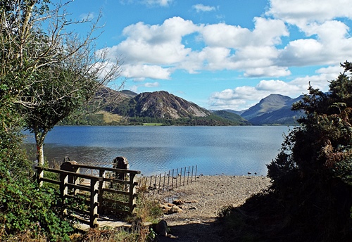
The second car park, Bleach Green, was at the south western corner of the lake where a short walk through a wooded area and along a wide pleasant path took me to the widest and more open part. A small weir allowed water from the lake to feed the River Ehen and the views down the lake itself were stunning.
When I’d first thought about going to Ennerdale I’d also thought about walking all the way round the lake – at only two-and-a-half miles long and less than a mile wide at its widest point it certainly sounded doable – but that was before I’d read some information about the area on a ‘Lakes walking’ website. It seemed that a certain section of the path on the south side involved a fair bit of scrambling and ‘hands on rock’ – not a good idea with two dogs in tow so for safety and sanity I stuck to the western end of the lake.
A path close to the weir took me through an area of small trees and bracken before emerging close to the lakeside and several times I went down to the water’s edge to let Snowy and Poppie have a paddle. At one point I came across a couple of backpacks and a coolbag on the ground and just down below the path two ladies were having a lakeside picnic; they had chosen a great spot and it looked like they were having a nice time.
As I got round to the north side of the lake the path veered away from the water and took me through an area of scrubland; a little way ahead was a gate so I used that as my turn-round point and retraced my steps. About halfway along I saw something I hadn’t noticed before as I was too busy looking at the views over the lake. In a grassy clearing set back off the path was a bench and what appeared to be a good view over the nearby fields but the bench was occupied by a couple with an off-lead dog bigger than my two so I didn’t go for a closer look.
Back at the weir I found that corner of the lake was occupied by an older teenager/young man about to set off on a stand-up paddle board. I watched him for a while as he paddled further out across the water; he was obviously on his own and with no life jacket so I hoped he would be okay if he fell in, especially as there was a “Danger – deep water – No swimming” sign close to where he’d left his things.
With the final couple of shots taken I headed back to the van for the return drive to the camp site – it had been a lovely few hours out and I’d been very impressed by the views around Ennerdale. Since getting back home I’ve found out that there’s a cafe in the nearby village so with the possibility of being able to get a coffee and a snack that area is now on my ‘must return’ list of places.
The day after my visit to Silloth I’d wakened to a grey and drizzly morning which turned into a grey and drizzly afternoon so I stayed on site and only went out briefly to get a few supplies from Cockermouth. By 4pm it was raining properly, heavy rain which continued for the rest of the day and all through the night but by the following morning it was fine, the grey clouds were clearing away and the sunshine was back. Taking a chance that the day would improve even more I decided to drive over to the coast again, this time to revisit Workington harbour, Harrington and Whitehaven. There were still some grey clouds around when I got to Workington but they soon cleared from the west and it turned into a beautiful day.
Parking briefly near the beach I took a walk along the nearby pier/breakwater to the ugly square tower with the beacon light on its roof and which is one of the two official west coast starting points of the C2C cycle route. Many people refer to C2C as being Coast-to-Coast but it actually means what it says – Sea-to-Sea. There was nothing special about the tower but round the back was a circle set on the ground and showing the distances from there to various other places, presumably as the crow flies, though I can’t see what connection it has to the C2C.
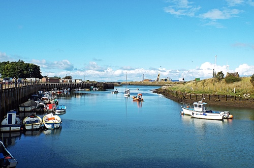
Driving past the harbour entrance and the port on the far side of the river a left turn took me to Town Quay on the riverside. With a mixture of new houses and older small commercial premises it was a long quiet road with pink pavements, pleasant roadside parking areas, colourful planters on the railings and benches overlooking the river where many fishing boats and a few pleasure craft were moored. At the harbour end of the road was a patch of rough ground with a few private garages; the pavement ended just beyond the garages and I came to a small quay and the attractive yacht harbour which I didn’t manage to photograph properly on my previous visit.
From the riverside I drove the three miles down to Harrington but this time I didn’t go anywhere near the harbour. While researching the area for a previous post a while ago I came across something on another blog which mentioned some pastel coloured houses on Rose Hill, a single sided street on the hillside overlooking the parkland and the harbour, so checking out the area on Google maps street view I thought it was worth taking a look.
The Cumbrian Coast railway line ran between Rose Hill and the parkland and the road took me under a viaduct, past the end of the harbour, back over the line via a bridge and up the hill, where there were several gravel parking areas set in the wide grass verges opposite the houses. The top end of the street narrowed into a farm track with vehicle access only to the farm and another couple of houses up there, and the steepness of the hillside meant that the railway line ran out of sight below street level so there was an uninterrupted view over the parkland, harbour and coastline.
The top two houses were large double-fronted 1950s semis while the rest of the properties were split into two long terraces of Georgian and Victorian houses and cottages, many painted in pastel colours and all well kept with small neat front gardens. It was a lovely street well worth a few photos and I was glad I’d found out about it even if it was by accident on the internet.
From Harrington I went the five and a half miles down to Whitehaven, leaving the van in Tesco’s car park and walking along the Millennium Promenade past the harbour and marina. At the far side of the harbour a flight of wide steps and a path led up the steep hillside to the Candlestick. Reputed to have been modelled on a candlestick in Whitehaven Castle, the ancestral home of the Lowther family, it was built by architect Sydney Smirke as a ventilation shaft for the Wellington Pit which was sunk in 1840 and closed in 1933. The surface buildings of the pit were also designed and built by Smirke and were in the form of a castle with a keep, turrets and crenellated walls.
On May 11th 1910 Wellington Pit became the scene of Cumbria’s worst mining disaster when 136 men and boys died following an explosion and fire deep underground. Just below the Candlestick were the remains of the surface buildings’ retaining walls and on the ground a colourful modern mosaic commemorating the mine workers, although Wellington Pit wasn’t the only Whitehaven mine to suffer fatalities. Not far from the mosaic was quite an attractive white building, Wellington Lodge, which was once the entrance lodge for Wellington pit but is now used as a coastguard base.
Although I’d been up to the Candlestick a couple of years ago I hadn’t gone any further along the hillside so anything beyond Wellington Lodge was all new to me. A tarmac lane and a footpath led from the Lodge to a residential road further up the hill and halfway along, set up above the grass, was a paved area with a modern circular seat and good views over the harbour and town. Surrounding the seat were several curved paving slabs showing the goods once imported into Whitehaven and the countries they came from.
Along the road was a building which looked very much like a ruined castle but was actually the remains of the Duke Pit Fan House built in 1836. It initially housed a steam-driven fan wheel measuring 8ft in diameter which circulated 23,000 cubic feet of air per minute through the mine workings below, but in 1870 a much larger fan wheel was installed – at 36ft in diameter it was capable of circulating 70,000 cubic feet of air per minute. Duke Pit suffered three explosions between 1842 and 1844 with the 1844 explosion killing eleven men and eleven horses. The pit closed later that same year and the shaft was then used to ventilate the nearby Wellington Pit. The fan house itself is now regarded as being the best surviving example in the country.
Just beyond the fan house the path doubled back on itself and took me lower down the hillside to a narrow flight of stone steps which led to the car park of the Beacon Museum opposite part of the marina. Heading back towards the Millennium Promenade I came to the bandstand, a modern structure with a tent-like canopy and a colourful circular mosaic floor, then along the promenade itself I found two random metal fish. I’d already seen several of these on a corner and as an art installation, if that’s what they were, they looked quite attractive but these two didn’t seem to serve any purpose except maybe as a trip hazard for someone too busy looking at their phone.
In the late afternoon sun it was a very pleasant walk along the promenade and I would have liked to sit on a bench and watch the world go by for a while but my two hours were almost up on Tesco’s car park so I had to get back to the van. Since getting back home I’ve realised that there are a couple of other places in Whitehaven which I’d like to take a look at so no doubt I’ll be making another visit during my next holiday in that area – it’s now on my list.
A day where I meet a big man and his dog sitting on a bench….
It was another morning of blue sky and fluffy white clouds, just right for a drive over to Silloth on the coast, but unfortunately the further west I went the more the clouds joined up until the blue disappeared and Silloth itself became very dull and grey, although the sun did occasionally manage to pop out from behind the clouds. The main reason for going there was to visit Christ Church situated on a very pleasant corner opposite Silloth Green – I’d been in there two years ago and found it to be a lovely place with unusual interior brickwork but sadly a revisit this time was out of the question as the place was closed due to building work being carried out inside.
Further along the wide cobbled road I came to the replica Lockheed Hudson Bomber installed at the edge of the green in 2018. Sunday April 1st that year marked the 100th birthday of the Royal Air Force and to commemorate the occasion the replica WW2 plane was constructed by apprentices at the Gen2 technology college near Workington and gifted to Silloth town. A raised flower bed was created round it by the Town Council’s ground maintenance team and planted up in the blue, white and red colours of an RAF roundel although a bit of yellow now seems to have crept in from somewhere.
The Lockheed Hudson was an American-built light bomber and coastal command reconnaissance aircraft designed by Clarence ‘Kelly’ Johnson. A military conversion of the Lockheed Model 14 Super Electra airliner, it was built for the RAF shortly before the outbreak of WW2, serving through the war years with Coastal Command and in transport and training roles as well as delivering agents into occupied France.
Silloth Airfield, originally designed to be used by RAF Maintenance Command, opened in June 1939 but was handed over to Coastal Command during November that year, with No.1 (Coastal) Operational Training Unit being responsible for training pilots and crews from the UK and Allied countries. During the Unit’s time at Silloth 64 Lockheed Hudsons were lost – at least 24 of those crashed on take-off or landing while a further 17 went down in the nearby Solway estuary, resulting in a number of fatalities and later earning the area the nickname of ”Hudson Bay”. The war graves in Christ Church cemetery and the name ”Hudson Bay” remain today as a poignant reminder of the young men that so many families lost.
Across the road from the replica plane was the Silloth branch of the Royal Air Force Association club and on part of the side wall round the corner was a very colourful artwork, while further along on the edge of a small and pleasant green was a bus shelter with some artwork on its inside walls. Across the green was Silloth Discovery Centre and Tourist Information, housed in an attractive building which looked like it had once been a church but was actually the old St. Paul’s School, said to be the first public building in Silloth. A short pathway from the green took me past a primary school and back out onto the cobbled road close to a couple of rows of attractive terraced houses and a little way along, facing the pedestrian promenade and the sea, was the Big Fella sculpture.
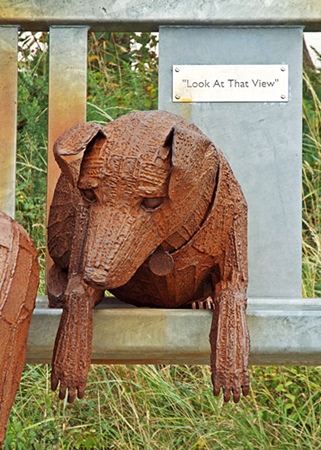
The sculpture, made of steel and almost 9ft tall, was produced by Durham artist Ray Lonsdale and unveiled on August 1st 2019, erected in memory of Silloth resident Peter Richardson who passed away in 2017 at the age of 72. Peter had seen one of Ray’s sculptures elsewhere in the country and was so impressed that he tracked down the artist and asked if he could do something for Silloth Green. Sadly he passed away before he saw his wish fulfilled but his son was determined to complete the job his dad had started and provide a sculpture as a gift for the town.
Peter had always loved the view looking across the sea to Criffel in Scotland and was often heard to say “Look at that view” so the sculpture, while not being a copy of Peter himself, depicts a man taking in the beautiful sea views and shielding his eyes from the evening sun while his dog lies beside him on the bench. The dog must have looked quite realistic to Snowy and Poppie as they both seemed curious and Snowy even stretched up to sniff its nose.
From the sculpture I walked along the promenade until the docks got in the way then headed back north along the green. Planned landscaping along the green began to develop from the mid 19th century; in 1859 the seawater baths were built and at each high tide a steam engine would pump gallons of water from the sea to fill the plunge type pools. A century later a new sea wall and repairs to the promenade in the 1950s gave Silloth Green a chance to re-invent itself; the building which had once housed the Victorian baths and a later tea room was transformed into an amusement place and a miniature railway and paddling pool became popular attractions to both visitors and local people.
Fast forward to 2010 and a successful bid for Heritage Lottery funding enabled the restoration and enhancement of the Green, with work including the restoration of the pagoda and Edwardian toilets, the replanting of the rose garden and the installation of a children’s water splash park. Unfortunately the rose garden was now a bit of an overgrown mess; one of those currently fashionable ‘bug hotels’ sits in the middle of it and what were supposed to be flower beds contained a mish-mash of everything except roses.
East Cote Lighthouse was established in 1841 as a navigational aid for ships sailing across the Solway Firth between Port Carlisle and Annan; originally manned by Silloth man Edward Dalglish it was later maintained by the Silloth Port Authority. As the navigable channels in the Solway changed with the tides the lighthouse was reportedly placed on a short rail track so that at any given time it could be moved to shine a light down the latest navigable channel whilst also working in conjunction with the Silloth Pierhead lighthouse. In 1914 it was fixed in its current position with a small keeper’s cabin below the tower, then in 1997 it was rebuilt in its original style.
Although there were several patches of blue sky showing through the clouds the sun didn’t really stay out long enough to make visiting somewhere else worthwhile so abandoning my intention to drive down to Allonby and spend some time there I headed back to the camp site – Allonby wasn’t going to disappear so I could always visit another time.
It was another lovely morning full of sunshine, blue sky and fluffy white clouds, with the nearby fells so clear they seemed to be within touching distance so I knew just what I was going to do with my day. Distance-wise, this time I was only driving the 11 miles to Keswick but making a photo stop on the way.
There aren’t many places on Bassenthwaite Lake where you can actually get to the water but the north west corner is one of them and it was on my route from the camp site to Keswick. Leaving the van in the first of two small parking areas set back off the lane I went down through the trees and walked along the lakeside until I could go no further without getting very wet feet. Heading south down the A66 a while later the views across the lake were so lovely that I pulled up briefly in a lay-by to get another couple of shots before continuing on to Keswick.
A couple of days before the start of the holiday a suggestion had been made via email that if I wanted (quote) “a nice fell walk that doesn’t involvemountaineering but gives stupendous views” I might like to consider Latrigg, so having checked it out on Google maps that’s where I was headed. Parking was on a residential road on the outskirts of Keswick where an unadopted lane ran for quite a distance, taking me over the A66 to the start of the footpath up the fell. An information board showed the various paths and bridleways around and up the fell and as the main path in front of me seemed to be quite steep and uneven I decided to take a level path through the woods instead.
All went well for quite a distance and it was a very pleasant walk but then I hit a big problem – a huge area of woodland extending almost to the top of the hillside had been felled and ripped out by machinery and any semblance of a footpath had completely disappeared. With nothing but piles of dried out branches and vegetation and the remains of tree trunks sticking up everywhere it looked like the aftermath of the apocalypse. So I had two choices – retrace my steps to the main path or try to find a way up the hillside. I suppose I should really have turned back but dogged determination made me continue, using the machinery tracks as a path.
The first hundred yards or so weren’t too bad but then the machinery tracks went vertically up the extremely steep hillside. To make matters worse some of them held pools of stinky, muddy stagnant water and I often had to walk along the top of the banked up earth in the centre – negotiating tree stumps and dead vegetation and trying not to let myself or the dogs slip into muddy water was certainly a challenge. I should really have taken a photo to show just how steep the hillside was but concentrating on getting up to the top without doing myself a mischief meant I wasn’t really in the mood to use the camera.
The start of my epic climb
Looking backLooking along the fell – a quarter of the way up, still a long way to go
Just over halfway up and over to my right was a barbed wire fence and a wooden gate leading to a very pleasant looking grassy part of the hillside – if I could get to it the rest of the climb might be a bit easier. There was only one thing wrong – running down the hillside in a dip between me and the gate was a stream which needed to be crossed. Carefully picking my way down into the dip I found a very narrow bit of the stream where I could step across via a couple of flat stones then up the other side of the dip I finally reached the gate.
Unfortunately it was fastened shut but that was no problem, I just posted the dogs through the bottom of it then climbed over – and what a difference there was in the terrain. A narrow but smooth and level grassy track led through an area of russet coloured bracken, the few small trees dotted about sported their autumn berries and the views to the south and east were opening up in front of me – it all looked rather lovely. It wasn’t long though before I had to start climbing again; the hillside was just as steep as before but at least the grassy track made things a bit easier.
Finally, just over an hour after I started my epic climb, I reached the top of the hillside and the gate which took me onto the ridge of the fell. It was a joy to see some reasonably flat land and after such a steep and strenuous climb I felt like I should have planted a flag there to celebrate conquering the mountain. My climb hadn’t been without incident though – several times I’d been attacked by bits of dried out tree lying on the ground and the back of my legs had sustained several scratches which still haven’t completely disappeared.
I hadn’t been on top of the fell for long when four RAF jets came out of nowhere and flew at speed one after the other right over my head. They were very loud and very low, so low that they only just skimmed the top of the fell and the earsplitting noise terrified Snowy but fortunately they were gone in seconds, disappearing out of sight up Bassenthwaite Lake.
The summit of Latrigg looking eastLooking south eastView north west towards Bassenthwaite LakeView over Keswick to Derwentwater and beyond
After spending some time taking in the views and recovering from my climb I set off on the downward journey, this time on the path that I should really have gone up. It was a fairly easy-to-walk zig-zag route which gave me some more lovely views over other nearby fells, with the last few hundred yards of the path being the steep bit which I should have gone up at the start. Eventually I was back on the unadopted lane crossing over the A66 and my last shot of the day was taken just before I reached the road where I’d left the van.
View along the Vale of Keswick to Bassenthwaite
At 1,207ft Latrigg is one of the smaller fells – I’d climbed up it, walked down it, got some good photos in the process and the dogs had a good walk, now it was time to go back to the camp site and relax for the rest of the day.
While writing this post I came across a photo on the internet which I’m including here. The screen capture from Google maps shows the hillside before the Forestry Commission got their machines on it – the blue line is where I walked through the woods, the yellow shows the area of trees which have been felled and the red is my route up the hillside. The photo shows the steepness of the hillside – although the bottom of the hill is obscured the red line shows part of my route to the top, with the white spot denoting the gate I climbed over.
Photo credit – The Keswick Reminder
Would I go up Latrigg Fell again? At the moment the jury’s out on that one but I won’t deny that the views were certainly ‘stupendous’ so if I’m on another camping holiday in Cumbria and the weather is right then maybe – although if I do I’ll make sure I use the proper path to get there.
A day where I end up almost in Scotland. Well not quite, but it was only just across the water….
Wall to wall sunshine and blue sky on the first dog walk showed the promise of a lovely day to come, with an early morning mist slowly clearing from the valley where the river ran down below the fields. Other than the occasional bleat of a sheep everywhere was completely quiet and it all looked so lovely that I went back to the tent for the camera and repeated the walk just so I could take a few photos.
My destination for the day was Bowness-on-Solway and Port Carlisle, two villages within a mile or so of each other on the eastern end of the Solway Firth estuary where the rivers Esk and Eden meet. I’d seen a photo of Bowness ages ago – on someone else’s blog I think – and though there didn’t seem to be much there it had intrigued me enough to want to go there on a nice day.
Set just off the road on the western edge of Bowness was a small parking area with just about enough space for half a dozen cars. Unfortunately it was full and the road through the village was too narrow to park anywhere else so I drove on to Port Carlisle and was lucky enough to find a small lay-by close to a section of Hadrian’s Wall Path at the start of the village. Now to be honest I really don’t know what some people find so fascinating about walking 84 miles from coast to coast along a path which supposedly follows the line of an old wall, much of which now doesn’t exist anyway, but for curiosity’s sake I went along the short section through the village.
The village itself is little more than a hamlet of less than 100 houses mainly situated on the landward side of the coast road. Originally called Fisher’s Cross it was renamed Port Carlisle in 1819 when it became the sea terminus of the short lived Carlisle Canal. The Hadrian’s Wall Path actually bypassed the village, running behind a handful of houses on the seaward side of the road where not far from the shore were the remains of a long brick-built wall which was once the sea wharf for the port.
Through an area of scrubland I eventually found an offshoot from the path which took me back onto the road at the far end of the village and a hundred yards along I found the Wesleyan Methodist Chapel, built of brick in 1861 though much altered internally over the years. In 1873 it had enough pews to seat a congregation of 150 but by 1940 these had been reduced to seat 90, then by 1980 they had been further reduced to seat 60. In the years since then the front of the chapel has been partitioned off to provide a lobby and a small kitchen, the ceiling has been boarded in and the remaining pews replaced with chairs.
Delighted to find the chapel open I went in to take a quick look and found a simple little place with just two identical stained glass windows and a rostrum at the far end, while a table at one side and the absence of any rows of chairs suggested that the building is probably used for things other than worship.
Walking along the road through the village I passed a couple of terraces of Georgian houses. The first row was fronted by a long cobbled area used for residents’ parking while the second row had very small front gardens, then at the end of the row was the Hope & Anchor pub with the Port Carlisle Bowling Club opposite. Between the road and the bowling green was a long, wide and very empty car park with a notice on the fence saying it was for the use of club members only. To be honest I thought that was a bit selfish when any visitors to the area have to find somewhere to park at the edge of the narrow road; I’m sure the car park is big enough to allow a just few spaces to be set aside for visitors, especially if there’s no-one there playing bowls.
Driving back to Bowness I was lucky enough to find just one available space in the small parking area with extensive views across the water to Annan Beach in Scotland and the outskirts of Annan itself. Leaving the van I walked back through the village, an attractive little place with a primary school, the King’s Arms pub, a bistro and a mixture of old cottages and more modern houses and bungalows with well kept gardens.
Sharing the same open courtyard with the bistro was a very small cafe with two or three picnic benches outside. I would have loved to stop for a coffee and a snack but several fancy hens and a whole load of tiny little chicks were roaming about and sitting under the tables – I didn’t want Snowy to grab an early dinner so I kept walking to the far end of the village then turned and retraced my steps back to the van, and with one final shot of the nearby signpost I set off on the drive back to the camp site.
Since returning home from the holiday I’ve found out about a few things of interest which I missed that day, both in Bowness and Port Carlisle, and though I won’t have the opportunity to go back again this year I’ll certainly make a longer return visit to both places the next time I’m camping in north west Cumbria.