
Category: Lake District & Cumbria


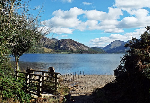
Somewhere new – Ennerdale Water
After a bit of a misty start it turned into a beautiful sunny morning and for the last full day of the holiday I was going to somewhere I hadn’t previously been. Ennerdale Water is the most westerly of all the lakes and according to various sources is the least visited – with my preference for quieter places I was looking forward to a good dog walk where hopefully I wouldn’t meet too many people.
It was a nice easy drive from Cockermouth down the A5086 then round the country lanes and through Ennerdale Bridge village. With a choice of two car parks I went to Bowness Knott on the north side of the lake first but didn’t stay long. The car park itself was set among tall conifers at the edge of a large forest on the narrower part of the lake; with the sun behind the higher fells to the south quite a bit of the area was in shade so I only took a short walk before driving to the other car park, making a couple of brief photo stops on the way.


The second car park, Bleach Green, was at the south western corner of the lake where a short walk through a wooded area and along a wide pleasant path took me to the widest and more open part. A small weir allowed water from the lake to feed the River Ehen and the views down the lake itself were stunning.
When I’d first thought about going to Ennerdale I’d also thought about walking all the way round the lake – at only two-and-a-half miles long and less than a mile wide at its widest point it certainly sounded doable – but that was before I’d read some information about the area on a ‘Lakes walking’ website. It seemed that a certain section of the path on the south side involved a fair bit of scrambling and ‘hands on rock’ – not a good idea with two dogs in tow so for safety and sanity I stuck to the western end of the lake.


A path close to the weir took me through an area of small trees and bracken before emerging close to the lakeside and several times I went down to the water’s edge to let Snowy and Poppie have a paddle. At one point I came across a couple of backpacks and a coolbag on the ground and just down below the path two ladies were having a lakeside picnic; they had chosen a great spot and it looked like they were having a nice time.


As I got round to the north side of the lake the path veered away from the water and took me through an area of scrubland; a little way ahead was a gate so I used that as my turn-round point and retraced my steps. About halfway along I saw something I hadn’t noticed before as I was too busy looking at the views over the lake. In a grassy clearing set back off the path was a bench and what appeared to be a good view over the nearby fields but the bench was occupied by a couple with an off-lead dog bigger than my two so I didn’t go for a closer look.


Back at the weir I found that corner of the lake was occupied by an older teenager/young man about to set off on a stand-up paddle board. I watched him for a while as he paddled further out across the water; he was obviously on his own and with no life jacket so I hoped he would be okay if he fell in, especially as there was a “Danger – deep water – No swimming” sign close to where he’d left his things.


With the final couple of shots taken I headed back to the van for the return drive to the camp site – it had been a lovely few hours out and I’d been very impressed by the views around Ennerdale. Since getting back home I’ve found out that there’s a cafe in the nearby village so with the possibility of being able to get a coffee and a snack that area is now on my ‘must return’ list of places.
Workington harbour, Harrington & Whitehaven
The day after my visit to Silloth I’d wakened to a grey and drizzly morning which turned into a grey and drizzly afternoon so I stayed on site and only went out briefly to get a few supplies from Cockermouth. By 4pm it was raining properly, heavy rain which continued for the rest of the day and all through the night but by the following morning it was fine, the grey clouds were clearing away and the sunshine was back. Taking a chance that the day would improve even more I decided to drive over to the coast again, this time to revisit Workington harbour, Harrington and Whitehaven. There were still some grey clouds around when I got to Workington but they soon cleared from the west and it turned into a beautiful day.
Parking briefly near the beach I took a walk along the nearby pier/breakwater to the ugly square tower with the beacon light on its roof and which is one of the two official west coast starting points of the C2C cycle route. Many people refer to C2C as being Coast-to-Coast but it actually means what it says – Sea-to-Sea. There was nothing special about the tower but round the back was a circle set on the ground and showing the distances from there to various other places, presumably as the crow flies, though I can’t see what connection it has to the C2C.


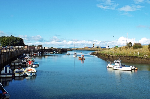
Driving past the harbour entrance and the port on the far side of the river a left turn took me to Town Quay on the riverside. With a mixture of new houses and older small commercial premises it was a long quiet road with pink pavements, pleasant roadside parking areas, colourful planters on the railings and benches overlooking the river where many fishing boats and a few pleasure craft were moored. At the harbour end of the road was a patch of rough ground with a few private garages; the pavement ended just beyond the garages and I came to a small quay and the attractive yacht harbour which I didn’t manage to photograph properly on my previous visit.


From the riverside I drove the three miles down to Harrington but this time I didn’t go anywhere near the harbour. While researching the area for a previous post a while ago I came across something on another blog which mentioned some pastel coloured houses on Rose Hill, a single sided street on the hillside overlooking the parkland and the harbour, so checking out the area on Google maps street view I thought it was worth taking a look.
The Cumbrian Coast railway line ran between Rose Hill and the parkland and the road took me under a viaduct, past the end of the harbour, back over the line via a bridge and up the hill, where there were several gravel parking areas set in the wide grass verges opposite the houses. The top end of the street narrowed into a farm track with vehicle access only to the farm and another couple of houses up there, and the steepness of the hillside meant that the railway line ran out of sight below street level so there was an uninterrupted view over the parkland, harbour and coastline.
The top two houses were large double-fronted 1950s semis while the rest of the properties were split into two long terraces of Georgian and Victorian houses and cottages, many painted in pastel colours and all well kept with small neat front gardens. It was a lovely street well worth a few photos and I was glad I’d found out about it even if it was by accident on the internet.


From Harrington I went the five and a half miles down to Whitehaven, leaving the van in Tesco’s car park and walking along the Millennium Promenade past the harbour and marina. At the far side of the harbour a flight of wide steps and a path led up the steep hillside to the Candlestick. Reputed to have been modelled on a candlestick in Whitehaven Castle, the ancestral home of the Lowther family, it was built by architect Sydney Smirke as a ventilation shaft for the Wellington Pit which was sunk in 1840 and closed in 1933. The surface buildings of the pit were also designed and built by Smirke and were in the form of a castle with a keep, turrets and crenellated walls.


On May 11th 1910 Wellington Pit became the scene of Cumbria’s worst mining disaster when 136 men and boys died following an explosion and fire deep underground. Just below the Candlestick were the remains of the surface buildings’ retaining walls and on the ground a colourful modern mosaic commemorating the mine workers, although Wellington Pit wasn’t the only Whitehaven mine to suffer fatalities. Not far from the mosaic was quite an attractive white building, Wellington Lodge, which was once the entrance lodge for Wellington pit but is now used as a coastguard base.


Although I’d been up to the Candlestick a couple of years ago I hadn’t gone any further along the hillside so anything beyond Wellington Lodge was all new to me. A tarmac lane and a footpath led from the Lodge to a residential road further up the hill and halfway along, set up above the grass, was a paved area with a modern circular seat and good views over the harbour and town. Surrounding the seat were several curved paving slabs showing the goods once imported into Whitehaven and the countries they came from.


Along the road was a building which looked very much like a ruined castle but was actually the remains of the Duke Pit Fan House built in 1836. It initially housed a steam-driven fan wheel measuring 8ft in diameter which circulated 23,000 cubic feet of air per minute through the mine workings below, but in 1870 a much larger fan wheel was installed – at 36ft in diameter it was capable of circulating 70,000 cubic feet of air per minute. Duke Pit suffered three explosions between 1842 and 1844 with the 1844 explosion killing eleven men and eleven horses. The pit closed later that same year and the shaft was then used to ventilate the nearby Wellington Pit. The fan house itself is now regarded as being the best surviving example in the country.


Just beyond the fan house the path doubled back on itself and took me lower down the hillside to a narrow flight of stone steps which led to the car park of the Beacon Museum opposite part of the marina. Heading back towards the Millennium Promenade I came to the bandstand, a modern structure with a tent-like canopy and a colourful circular mosaic floor, then along the promenade itself I found two random metal fish. I’d already seen several of these on a corner and as an art installation, if that’s what they were, they looked quite attractive but these two didn’t seem to serve any purpose except maybe as a trip hazard for someone too busy looking at their phone.


In the late afternoon sun it was a very pleasant walk along the promenade and I would have liked to sit on a bench and watch the world go by for a while but my two hours were almost up on Tesco’s car park so I had to get back to the van. Since getting back home I’ve realised that there are a couple of other places in Whitehaven which I’d like to take a look at so no doubt I’ll be making another visit during my next holiday in that area – it’s now on my list.
Sauntering round Silloth
A day where I meet a big man and his dog sitting on a bench….
It was another morning of blue sky and fluffy white clouds, just right for a drive over to Silloth on the coast, but unfortunately the further west I went the more the clouds joined up until the blue disappeared and Silloth itself became very dull and grey, although the sun did occasionally manage to pop out from behind the clouds. The main reason for going there was to visit Christ Church situated on a very pleasant corner opposite Silloth Green – I’d been in there two years ago and found it to be a lovely place with unusual interior brickwork but sadly a revisit this time was out of the question as the place was closed due to building work being carried out inside.
Further along the wide cobbled road I came to the replica Lockheed Hudson Bomber installed at the edge of the green in 2018. Sunday April 1st that year marked the 100th birthday of the Royal Air Force and to commemorate the occasion the replica WW2 plane was constructed by apprentices at the Gen2 technology college near Workington and gifted to Silloth town. A raised flower bed was created round it by the Town Council’s ground maintenance team and planted up in the blue, white and red colours of an RAF roundel although a bit of yellow now seems to have crept in from somewhere.
The Lockheed Hudson was an American-built light bomber and coastal command reconnaissance aircraft designed by Clarence ‘Kelly’ Johnson. A military conversion of the Lockheed Model 14 Super Electra airliner, it was built for the RAF shortly before the outbreak of WW2, serving through the war years with Coastal Command and in transport and training roles as well as delivering agents into occupied France.
Silloth Airfield, originally designed to be used by RAF Maintenance Command, opened in June 1939 but was handed over to Coastal Command during November that year, with No.1 (Coastal) Operational Training Unit being responsible for training pilots and crews from the UK and Allied countries. During the Unit’s time at Silloth 64 Lockheed Hudsons were lost – at least 24 of those crashed on take-off or landing while a further 17 went down in the nearby Solway estuary, resulting in a number of fatalities and later earning the area the nickname of ”Hudson Bay”. The war graves in Christ Church cemetery and the name ”Hudson Bay” remain today as a poignant reminder of the young men that so many families lost.

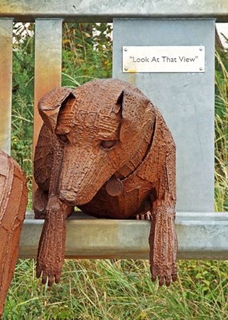
Across the road from the replica plane was the Silloth branch of the Royal Air Force Association club and on part of the side wall round the corner was a very colourful artwork, while further along on the edge of a small and pleasant green was a bus shelter with some artwork on its inside walls. Across the green was Silloth Discovery Centre and Tourist Information, housed in an attractive building which looked like it had once been a church but was actually the old St. Paul’s School, said to be the first public building in Silloth. A short pathway from the green took me past a primary school and back out onto the cobbled road close to a couple of rows of attractive terraced houses and a little way along, facing the pedestrian promenade and the sea, was the Big Fella sculpture.


The sculpture, made of steel and almost 9ft tall, was produced by Durham artist Ray Lonsdale and unveiled on August 1st 2019, erected in memory of Silloth resident Peter Richardson who passed away in 2017 at the age of 72. Peter had seen one of Ray’s sculptures elsewhere in the country and was so impressed that he tracked down the artist and asked if he could do something for Silloth Green. Sadly he passed away before he saw his wish fulfilled but his son was determined to complete the job his dad had started and provide a sculpture as a gift for the town.
Peter had always loved the view looking across the sea to Criffel in Scotland and was often heard to say “Look at that view” so the sculpture, while not being a copy of Peter himself, depicts a man taking in the beautiful sea views and shielding his eyes from the evening sun while his dog lies beside him on the bench. The dog must have looked quite realistic to Snowy and Poppie as they both seemed curious and Snowy even stretched up to sniff its nose.


From the sculpture I walked along the promenade until the docks got in the way then headed back north along the green. Planned landscaping along the green began to develop from the mid 19th century; in 1859 the seawater baths were built and at each high tide a steam engine would pump gallons of water from the sea to fill the plunge type pools. A century later a new sea wall and repairs to the promenade in the 1950s gave Silloth Green a chance to re-invent itself; the building which had once housed the Victorian baths and a later tea room was transformed into an amusement place and a miniature railway and paddling pool became popular attractions to both visitors and local people.
Fast forward to 2010 and a successful bid for Heritage Lottery funding enabled the restoration and enhancement of the Green, with work including the restoration of the pagoda and Edwardian toilets, the replanting of the rose garden and the installation of a children’s water splash park. Unfortunately the rose garden was now a bit of an overgrown mess; one of those currently fashionable ‘bug hotels’ sits in the middle of it and what were supposed to be flower beds contained a mish-mash of everything except roses.


East Cote Lighthouse was established in 1841 as a navigational aid for ships sailing across the Solway Firth between Port Carlisle and Annan; originally manned by Silloth man Edward Dalglish it was later maintained by the Silloth Port Authority. As the navigable channels in the Solway changed with the tides the lighthouse was reportedly placed on a short rail track so that at any given time it could be moved to shine a light down the latest navigable channel whilst also working in conjunction with the Silloth Pierhead lighthouse. In 1914 it was fixed in its current position with a small keeper’s cabin below the tower, then in 1997 it was rebuilt in its original style.


Although there were several patches of blue sky showing through the clouds the sun didn’t really stay out long enough to make visiting somewhere else worthwhile so abandoning my intention to drive down to Allonby and spend some time there I headed back to the camp site – Allonby wasn’t going to disappear so I could always visit another time.
Bassenthwaite Lake and Latrigg Fell
A day in which I climb a mountain the hard way….
It was another lovely morning full of sunshine, blue sky and fluffy white clouds, with the nearby fells so clear they seemed to be within touching distance so I knew just what I was going to do with my day. Distance-wise, this time I was only driving the 11 miles to Keswick but making a photo stop on the way.
There aren’t many places on Bassenthwaite Lake where you can actually get to the water but the north west corner is one of them and it was on my route from the camp site to Keswick. Leaving the van in the first of two small parking areas set back off the lane I went down through the trees and walked along the lakeside until I could go no further without getting very wet feet. Heading south down the A66 a while later the views across the lake were so lovely that I pulled up briefly in a lay-by to get another couple of shots before continuing on to Keswick.


A couple of days before the start of the holiday a suggestion had been made via email that if I wanted (quote) “a nice fell walk that doesn’t involve mountaineering but gives stupendous views” I might like to consider Latrigg, so having checked it out on Google maps that’s where I was headed. Parking was on a residential road on the outskirts of Keswick where an unadopted lane ran for quite a distance, taking me over the A66 to the start of the footpath up the fell. An information board showed the various paths and bridleways around and up the fell and as the main path in front of me seemed to be quite steep and uneven I decided to take a level path through the woods instead.


All went well for quite a distance and it was a very pleasant walk but then I hit a big problem – a huge area of woodland extending almost to the top of the hillside had been felled and ripped out by machinery and any semblance of a footpath had completely disappeared. With nothing but piles of dried out branches and vegetation and the remains of tree trunks sticking up everywhere it looked like the aftermath of the apocalypse. So I had two choices – retrace my steps to the main path or try to find a way up the hillside. I suppose I should really have turned back but dogged determination made me continue, using the machinery tracks as a path.
The first hundred yards or so weren’t too bad but then the machinery tracks went vertically up the extremely steep hillside. To make matters worse some of them held pools of stinky, muddy stagnant water and I often had to walk along the top of the banked up earth in the centre – negotiating tree stumps and dead vegetation and trying not to let myself or the dogs slip into muddy water was certainly a challenge. I should really have taken a photo to show just how steep the hillside was but concentrating on getting up to the top without doing myself a mischief meant I wasn’t really in the mood to use the camera.


Just over halfway up and over to my right was a barbed wire fence and a wooden gate leading to a very pleasant looking grassy part of the hillside – if I could get to it the rest of the climb might be a bit easier. There was only one thing wrong – running down the hillside in a dip between me and the gate was a stream which needed to be crossed. Carefully picking my way down into the dip I found a very narrow bit of the stream where I could step across via a couple of flat stones then up the other side of the dip I finally reached the gate.
Unfortunately it was fastened shut but that was no problem, I just posted the dogs through the bottom of it then climbed over – and what a difference there was in the terrain. A narrow but smooth and level grassy track led through an area of russet coloured bracken, the few small trees dotted about sported their autumn berries and the views to the south and east were opening up in front of me – it all looked rather lovely. It wasn’t long though before I had to start climbing again; the hillside was just as steep as before but at least the grassy track made things a bit easier.


Finally, just over an hour after I started my epic climb, I reached the top of the hillside and the gate which took me onto the ridge of the fell. It was a joy to see some reasonably flat land and after such a steep and strenuous climb I felt like I should have planted a flag there to celebrate conquering the mountain. My climb hadn’t been without incident though – several times I’d been attacked by bits of dried out tree lying on the ground and the back of my legs had sustained several scratches which still haven’t completely disappeared.
I hadn’t been on top of the fell for long when four RAF jets came out of nowhere and flew at speed one after the other right over my head. They were very loud and very low, so low that they only just skimmed the top of the fell and the earsplitting noise terrified Snowy but fortunately they were gone in seconds, disappearing out of sight up Bassenthwaite Lake.


After spending some time taking in the views and recovering from my climb I set off on the downward journey, this time on the path that I should really have gone up. It was a fairly easy-to-walk zig-zag route which gave me some more lovely views over other nearby fells, with the last few hundred yards of the path being the steep bit which I should have gone up at the start. Eventually I was back on the unadopted lane crossing over the A66 and my last shot of the day was taken just before I reached the road where I’d left the van.


At 1,207ft Latrigg is one of the smaller fells – I’d climbed up it, walked down it, got some good photos in the process and the dogs had a good walk, now it was time to go back to the camp site and relax for the rest of the day.
While writing this post I came across a photo on the internet which I’m including here. The screen capture from Google maps shows the hillside before the Forestry Commission got their machines on it – the blue line is where I walked through the woods, the yellow shows the area of trees which have been felled and the red is my route up the hillside. The photo shows the steepness of the hillside – although the bottom of the hill is obscured the red line shows part of my route to the top, with the white spot denoting the gate I climbed over.


Would I go up Latrigg Fell again? At the moment the jury’s out on that one but I won’t deny that the views were certainly ‘stupendous’ so if I’m on another camping holiday in Cumbria and the weather is right then maybe – although if I do I’ll make sure I use the proper path to get there.
Bowness-on-Solway and Port Carlisle
A day where I end up almost in Scotland. Well not quite, but it was only just across the water….
Wall to wall sunshine and blue sky on the first dog walk showed the promise of a lovely day to come, with an early morning mist slowly clearing from the valley where the river ran down below the fields. Other than the occasional bleat of a sheep everywhere was completely quiet and it all looked so lovely that I went back to the tent for the camera and repeated the walk just so I could take a few photos.


My destination for the day was Bowness-on-Solway and Port Carlisle, two villages within a mile or so of each other on the eastern end of the Solway Firth estuary where the rivers Esk and Eden meet. I’d seen a photo of Bowness ages ago – on someone else’s blog I think – and though there didn’t seem to be much there it had intrigued me enough to want to go there on a nice day.
Set just off the road on the western edge of Bowness was a small parking area with just about enough space for half a dozen cars. Unfortunately it was full and the road through the village was too narrow to park anywhere else so I drove on to Port Carlisle and was lucky enough to find a small lay-by close to a section of Hadrian’s Wall Path at the start of the village. Now to be honest I really don’t know what some people find so fascinating about walking 84 miles from coast to coast along a path which supposedly follows the line of an old wall, much of which now doesn’t exist anyway, but for curiosity’s sake I went along the short section through the village.
The village itself is little more than a hamlet of less than 100 houses mainly situated on the landward side of the coast road. Originally called Fisher’s Cross it was renamed Port Carlisle in 1819 when it became the sea terminus of the short lived Carlisle Canal. The Hadrian’s Wall Path actually bypassed the village, running behind a handful of houses on the seaward side of the road where not far from the shore were the remains of a long brick-built wall which was once the sea wharf for the port.


Through an area of scrubland I eventually found an offshoot from the path which took me back onto the road at the far end of the village and a hundred yards along I found the Wesleyan Methodist Chapel, built of brick in 1861 though much altered internally over the years. In 1873 it had enough pews to seat a congregation of 150 but by 1940 these had been reduced to seat 90, then by 1980 they had been further reduced to seat 60. In the years since then the front of the chapel has been partitioned off to provide a lobby and a small kitchen, the ceiling has been boarded in and the remaining pews replaced with chairs.
Delighted to find the chapel open I went in to take a quick look and found a simple little place with just two identical stained glass windows and a rostrum at the far end, while a table at one side and the absence of any rows of chairs suggested that the building is probably used for things other than worship.


Walking along the road through the village I passed a couple of terraces of Georgian houses. The first row was fronted by a long cobbled area used for residents’ parking while the second row had very small front gardens, then at the end of the row was the Hope & Anchor pub with the Port Carlisle Bowling Club opposite. Between the road and the bowling green was a long, wide and very empty car park with a notice on the fence saying it was for the use of club members only. To be honest I thought that was a bit selfish when any visitors to the area have to find somewhere to park at the edge of the narrow road; I’m sure the car park is big enough to allow a just few spaces to be set aside for visitors, especially if there’s no-one there playing bowls.
Driving back to Bowness I was lucky enough to find just one available space in the small parking area with extensive views across the water to Annan Beach in Scotland and the outskirts of Annan itself. Leaving the van I walked back through the village, an attractive little place with a primary school, the King’s Arms pub, a bistro and a mixture of old cottages and more modern houses and bungalows with well kept gardens.
Sharing the same open courtyard with the bistro was a very small cafe with two or three picnic benches outside. I would have loved to stop for a coffee and a snack but several fancy hens and a whole load of tiny little chicks were roaming about and sitting under the tables – I didn’t want Snowy to grab an early dinner so I kept walking to the far end of the village then turned and retraced my steps back to the van, and with one final shot of the nearby signpost I set off on the drive back to the camp site.


Since returning home from the holiday I’ve found out about a few things of interest which I missed that day, both in Bowness and Port Carlisle, and though I won’t have the opportunity to go back again this year I’ll certainly make a longer return visit to both places the next time I’m camping in north west Cumbria.
Mooching round Maryport
In which I find an unexpected and economical solution to the tv problem….
My quest that day was to go in search of a new tv so the fact that it was another grey and cloudy morning didn’t really matter. Just like my previous tv the current one came from Tesco four years ago – one of their own brand – and I’d always been happy with it so Tesco in Workington was my first port of call. Now this place calls itself a Superstore but in reality it’s not that big – you could put it in one corner of my own local store – and it didn’t seem to have an electrical department so I had to have a rethink. I knew from my previous holiday that there was a Currys/PC World not far away so I decided to try there and was so glad I did.
Unfortunately the cheapest set they had was £179, far more than I was willing to pay just for a small bedroom tv I could also use when camping, however the very helpful assistant suggested a much cheaper alternative in the form of a small HD set top box which would connect to the tv by an HDMI cable, with the aerial plugged into the box instead of the tv itself. Now not being technically minded it took a minute or two to get my head round this, also I couldn’t believe the solution to my problem was so simple, but at £35 compared to the cost of a new tv it was a no-brainer so I bought one there and then.
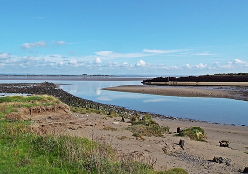
Driving back to the site from Workington took me through Maryport so I decided to stop off there for a mooch round and to give the dogs a decent walk. The road past the harbour and marina ended in a rough surfaced car park close to the beach and backed by a long sea wall at the top of a grassy slope, where the overgrown ruins of the old harbour master’s house stood on the corner. A pavement of rough sandstone slabs ran for quite a distance along the top of the slope so I walked to where it ended, took a shot of the view back towards Workington then retraced my steps and went down to the roadway.


At the entrance to the harbour was the old lighthouse, an octagonal cast iron tower on a single storey stone base, built in 1846 and almost 36ft tall. Thought to be one of the first of its type built in the UK it’s possibly one of the world’s oldest cast iron lighthouses. It was deactivated in 1996 after a smaller, 15ft high aluminium square tower powered by electricity was built at the end of the pier.


Needing to find a cash machine I drove back to the other side of the harbour, parked near the aquarium and took a wander into the town centre – what there is of it – where I found a couple of bits of street art. The multi-coloured sweets were actually part of a window covering inside a shop but I liked their bright colours enough to take a photo.
Just to one side of the harbourside bridge over the River Ellen was A Fishy Tale, a sculpture of fishermen created by Colin Telfer, a local artist whose workshop is in the town centre. The sculpture was created using a unique process of bonding haematite iron ore from Florence Mine, Egremont, with resin and Telfer is the first artist to use iron ore in sculpture.


Although there were other photos I wanted to take there was no sign of any sunshine anywhere so I decided to call it a day and return to the camp site. Back at the tent the first thing I did was connect the new set top box to the tv and tune it in and I was really pleased when it found more channels than I’d had previously. So the problem of the broken aerial connection was well and truly solved without the purchase of a new tv and thanks to the very helpful Keaton at Currys/PC World, Workington, I was a very happy little bunny.
Wandering round Wigton
A day where I go looking for a new tv and find a lovely church….
After the sunshine of the previous day the second morning arrived cloudy and grey though still very warm. Activities around the farm started just after 8am and when I took Snowy and Poppie for their morning walk I found a large agricultural wood chipper making short work of a gigantic pile of tree trunks, with a couple of tractors and trailers running in relay taking the chippings up to the big barn at the top of the farm track.


The grey sky and low cloud seemed to be fairly widespread with no sign of clearing so I decided to stay on site, read a few chapters of my book and maybe indulge in a bit of daytime tv, something which I rarely do at home, however the tv itself had other ideas. As I moved it round to avoid the light reflection from the tent window the aerial connector came out of the back of the set and when I looked the connection port itself had broken off inside the set and there was no way of fixing it myself.
Later information from the site owner told me that there was a tv repair shop in Wigton, about 12 miles away; I’d been intending to visit the town at some point during the holiday anyway as I wanted to check out the heritage trail so it seemed like this day was as good as any even if the weather was still dull. I found the tv repair shop with no problem and while the tv could probably have been fixed it couldn’t be done for a week or so and the cost of the repair could possibly be more than the small 24″ set was worth. It looked like I would have to search out a new one from somewhere but not before I’d had a walk round the heritage trail.
Starting from where I left the van the first building I came to was St. Mary’s Church. It dates from the late 1700s and was modelled on St. Michael’s in Workington, though I’m saving any other details for another time as it really deserves a post of its own. In front of the church, between the building and the road, was the old cobbled Corn Market, while on the south side was a row of traditional Georgian cottages built in the 1700s. On the north side was a row of cottages known as the Widows’ Hospital, built in 1723 following a bequest from the Rev John Thomlinson, Rector of Rothbury, for the widows of six Protestant clergymen from across the county of Cumberland.


Along the road and across on the other side was Wigton Methodist Church, built in 1883 and modernised inside in 2005, then back past St. Mary’s I came to Market Place and the George Moore Memorial. Built in 1872 and dedicated to Moore’s first wife Eliza Ray each of the four sides features a sculpture by the pre-Raphaelite sculptor Thomas Woolner, showing scenes of the Acts of Mercy with Eliza’s face above each one.


Across from the memorial was the former Kings Arms Hotel, originally a coaching inn where authors Charles Dickens and Wilkie Collins stayed while on their Lazy Tour of Two Idle Apprentices during the wet winter of 1857. Apparently they didn’t enjoy the town very much as Collins had previously fallen on Carrock Fell and twisted his ankle. The hotel was renovated in 1987 and when the wallpaper was stripped off it was found that Dickens had put his autograph on one of the walls.

Along the road to the left of Market Place was the Hare & Hounds, a pub and former shop which is now just one property. Built in the late 17th/early 18th century it’s one of the oldest pubs in Wigton and has been Grade ll listed since November 1984.
Back past the George Moore Memorial and down Station Road I came to the John Peel Theatre, built in 1884/85 as a barracks for the town’s Salvation Army corps. Wigton Theatre Club was formed in September 1952 by the head of Wigton Secondary School and the members spent the first ten years putting on plays, usually four each year, in the school hall, then in the Parish Rooms. In 1964 Redmayne’s Bespoke Tailors bought the barracks from the Salvation Army and rented the building to the theatre club, giving them substantial help in converting it into a theatre which was named after the John Peel of the well known song, then when the land around it was to be redeveloped in 1988 the club purchased the building in order to ensure its continued use as a theatre.


Round the corner from the theatre and on the way to the next building on the trail I came to a short alley leading to a couple of houses with unexpectedly pretty gardens. They weren’t connected in any way to the Heritage Trail but they looked so bright on such a dull day that I couldn’t resist taking a couple of photos.


The next building on the trail was the premises of Wilkinson Joinery on the site of the Old Corn Mill. Part of a 1775 rebuild of a much older building the current building served as a water-powered mill until the late 1920s; on the side wall are three original mill stones and a bronze plaque detailing the building’s history.
Across from the joinery place was a cottage with a large mural painted along its gable end wall. Steps at the side of its boundary wall led up to an open alleyway where part of the wall had been replaced by glass panels giving a view of the mural. It obviously depicts life in the past but so far I’ve been unable to find out what it signifies and why it’s there; it isn’t even mentioned in the heritage trail brochure.


At the end of the alleyway, which was quaintly named Birdcage Walk, I came to two more buildings with murals on their walls. Now home to the Free 4 All environmental charity they had once been part of the Old Cotton Mill, buildings which originally housed workers from the town’s thriving cotton industry in the 18th century.


At one corner of the car park where I’d left the van I came across The Pump and The Lamp. Originally situated in Market Place they had replaced a cross with a bell which was rung on each market day but which had burned down during a bonfire to celebrate Nelson’s victory at Trafalgar in 1805. The Pump and Lamp stayed in Market Place until 1872 when they were taken down to make way for the George Moore Memorial; after being stored for many years they were re-erected in their current spot in 1998. Heading back to the van my final shot, which had nothing to do with the heritage trail, was of a brightly coloured mural in an alleyway between the car park and one of the main streets.

There were actually 22 points of interest on the heritage trail but I didn’t photograph all of them as many of them now bear no resemblance to what they once were – while they may each have a bit of interesting information attached to them I don’t think shop fronts and takeaway places look particularly exciting.
Having spent quite some time walking round the heritage trail, and with no sign of the cloudy grey sky giving way to any sunshine, I decided to abandon my quest to find a new tv and return to the camp site. I could still watch a dvd if I wanted to and I had a couple of books to read so my tv search would continue another day.
September in Cumbria – return to the Lakes
A day in which I meet one of the most obnoxious people I’ve ever come across…
The middle Sunday of September saw me leaving home in drizzly rain and grey cloud for my second holiday at the Cumbrian farm site I love so much, though I hadn’t gone too far up the M6 before the rain stopped. By the time I’d got past the turn off for Lancaster and Morecambe the sun was shining, staying with me all the way to the camp site, and with just two caravans and two campervans across from the tent pitches it looked like it would be a quiet week.
Dotted about round the site are several picnic benches available for anyone to take onto their pitch and use while they are there so with the tent up and everything organised inside I’d dragged the nearest one, which was sitting in the middle of the grass at the end of the site, onto my pitch so I could fasten the dogs’ tie-out cables to the legs. There had been no-one around at the time but I was just about to make a brew later on when the guy from the caravan on the pitch diagonally opposite came across – and you’ll just have to imagine his tone of voice, which wasn’t very nice at all.
Pointing to the picnic bench he said “I was going to use that!!” Now to suddenly be spoken to like that by someone I’d never met before rather surprised and shocked me but before I could say anything he pointed to a bench further down the site and said “I suppose I’ll have to go and get that one now!!” and off he went, back into his caravan. I saw him a while later carrying another bench along the track through the site but he dumped it on the next-but-one pitch to mine and when I looked later I saw it was more of a child sized one so obviously not big enough for him.


Now I could ~ maybe ~ have understood this guy’s attitude if ‘my’ bench had been on or very close to his pitch, in which case I wouldn’t have taken it anyway, but it had been nowhere near his caravan so I didn’t know why he should decide to claim ownership of it and come over and verbally accost me. Needless to say, although I did speak to several other people on site over the course of the next ten days I kept well away from him and didn’t let the encounter spoil my holiday.
Creatures of the camp site
For my final holiday post I thought I would include some of the many creatures which call the camp site and farm their home. When I stayed there two years ago, aside from a large flock of sheep, 24,000 chickens and two dogs, the farm’s animal collection consisted of four pygmy goats, a small collection of hand reared/captive-bred birds in large aviaries and a few ponies which I never saw, however several changes since then have seen the addition of more birds, a couple of rheas, some alpacas and several rabbits.
The aviaries were set back in a pleasant area behind the facilities block, some of them having information plaques attached, while the ponies were in the field in front of my tent and the alpacas and rheas in paddocks to the side. A wide gravel track ran between the paddocks and down at the bottom were the goats, while the rabbits were in an enclosure at the corner of the farm track. It was all a very well thought out set up and reminded me a bit of a small-scale version of a wildlife park.

Snowy owl

Snowy owl

Great grey owl, native to North America, Europe and Asia


Burrowing owl, native to North and South America

Barn owl


Of course I couldn’t forget my own two camp site creatures, Snowy and Poppie. It was Snowy’s first holiday and while Poppie preferred to lie in the shade under the table Snowy liked to stand on the table so she could see what was going on around us, though she wasn’t happy about having to stay in her travel crate while I took the tent down on going home day.


