Month: March 2017


If ever there was a time to feel bad….
It was this morning. Why? Because I stood on Mouse. Yes, it probably sounds funny, and it looks funny now I’ve written it down, but it wasn’t at the time and I felt awful.
Now there are many ways to describe Mouse – peculiar, odd, a one-off, affectionate, funny, totally mad but also totally adorable, she’s all of those things and more, and she’s very much the favourite out of all three cats. This morning when I was getting ready to go out she was lying on the landing floor in a patch of sunlight near the bedroom door, but by the time I came out of the bedroom again I’d completely forgotten she was there and I stood right on her. Of course her natural reaction, along with the howl of pain, was to retaliate with her claws and they swiftly connected with my left ankle, but within seconds she had forgiven me and lay there purring away while I stroked her to say sorry.
It must have been ten minutes later when I noticed a couple of small streaks of fresh blood on the carpet where Mouse was lying – I must have injured her in some way and I was mortified. It seemed like I may be making a trip to the vet’s but a thorough inspection found the cause of the blood – a small nick about halfway along her tail. Other than that she was okay so the wound was given a quick clean up with a damp cotton wool ball and the problem was sorted. I’ve checked her tail a couple of times since then and thankfully it’s absolutely fine, showing no more signs of having been trodden on.

As I type this Mouse is sitting in one of her favourite places, on the rail at the top of the stairs; she’s probably already forgotten that I stood on her this morning but she’ll be getting an extra treat with her supper tonight to make up for it.
A walk up Winter Hill and some interesting facts
After several days of damp, dull and dreary weather which wasn’t exactly brilliant for dog walking, last Wednesday was a complete contrast with bright sunshine and a blue sky dotted with fluffy white clouds. It was far too nice to spend the whole time doing housework so at lunch time I drove myself and the dogs three miles up the road to do something I hadn’t done for almost twenty years – walk up to the top of Winter Hill.
Winter Hill is part of the West Pennine Moors above my home town and close to Belmont village, and in years gone by has been the site of mining activity, murders and several air disasters. At 1,498ft above sea level it’s also been home to a broadcasting and telecommunications site since the mid 1950s; currently owned and operated by Arqiva (formerly NTL Broadcasting) the tv mast up there is the second tallest mast in the UK and can be seen from many miles away. There are also a number of other much shorter telecommunication masts around the summit for mobile phones, professional mobile radio users and emergency services.
My walk started from the car park of the San Marino restaurant on the A675 at the outskirts of Belmont village. About fifty yards along from the car park and across the main road a wooden kissing gate signified the beginning of the path and I was glad I’d changed into my wellies when I got out of the van – the ground near the gate was wet and very muddy and there was no way to avoid it, but fortunately it became dry just a few yards further on. Right from the start the route took me on a steady climb up the hill, and though I’d started off with my jacket on the warm sun and the uphill walking soon had me taking it off and tying it round my waist. It wasn’t long before I left any road noise behind, and as there was no-one else around the only sound came from various skylarks and lapwings as they flew above the moorland; it was lovely and quiet and I stopped several times to take in the views and enjoy the peace.


Finally at the top of the hill there was a fence and another wooden kissing gate to go through, and a tarmac road leading into oblivion down the far side of the hill. Just at the other side of the gate were the two original stone gate posts, one bearing a plaque placed there on the 50th anniversary of a plane crash near there in 1958. A Silver City Airways charter plane was flying from the Isle of Man to Manchester when, due to thick cloud and navigational error, it crashed close to the summit of the hill and disintegrated on impact, leaving only the tail section still recognisable as part of an aircraft; thirty five people died and seven, including the pilot and air stewardess, were injured but survived. Other crashes in years previous to that have included several Spitfires and Hurricanes, and in September 1965 an RAF De Havilland Chipmunk flew into the hill in low cloud, fortunately without serious injury to the crew. The last crash up there occurred in October 1968 when a Cessna 172 force-landed on the west side of the hill.
A little way down the road from the gate posts was the tall tv mast surrounded on three sides by single storey buildings, and on the wall of one of these was the original plaque in memory of the victims of the 1958 plane crash, which came just three weeks after the Munich air disaster. Almost opposite the tv station was Scotsman’s Stump, an iron post with a plaque erected in 1912 in memory of a young man who was previously murdered there. His killer, a 22-year old collier from Belmont, was originally found guilty at local court but at a second trial in Lancaster he was found not guilty.


Standing close to the tv mast and looking up towards the top I tried to hazard a guess as to how tall it was – at least 250ft I thought, but how wrong I was – it’s actually 1,035ft. No wonder it can be seen from miles away! The original mast, which came into service in May 1956, was much shorter at only 450ft and though it was eventually dismantled and removed it could still be seen on the hill for many years after the tv services were transferred to the current mast.
Now covering a population of about 6.3 million people across the North West and into North Wales the current mast was constructed in 1964/5 and came into service in 1966; tubular in design it’s 9ft in diameter and engineers can ascend the inside of it to carry out any maintenance work. It also carries a series of bright red aircraft warning lights which swing inwards for maintenance and these make the mast visible in the dark for miles around.

From the summit of the hill on a clear day it’s possible to see Manchester city centre, the airport, Jodrell Bank Observatory in Cheshire, Southport, Liverpool, Snowdonia in North Wales, the Irish Sea, Snaefell in the Isle of Man, Blackpool tower, the Cumbrian mountains, the Peak District, the Pennines and the Yorkshire Dales, but unfortunately it was rather hazy in the distance just then so visibility was limited. With nothing much on the west side of the hill other than a vast expanse of moorland, and knowing that the road down would take me miles out of my way, I left the tv station behind and made my way back down the hill by the same path I’d gone up. If anything going down was actually harder than going up; the path was extremely rough in places with many deep ruts and pot holes so I had to watch where I was putting my feet. A twisted ankle could have been a distinct possibility but luckily the three of us managed to get back to road level without any accident or injury.


Back at the van I changed out of my wellies and towelled the dogs down as they’d just got dirty going through the muddy patch of ground near the gate, then I drove the three miles back down the road to home. My walk hadn’t been a particularly long one but in the warm sunshine it had been very pleasant in spite of the steep and rough terrain, and as Winter Hill is more or less on my doorstep I’ll try not to leave it another twenty years before I go up there again. And of course, this being the UK it’s done nothing but rain since that day so I’m glad I took the opportunity to do the walk while the weather was nice.

This week Jo’s Monday Walk shows the delights of the charming Italian walled city of Lucca where there’s scenery, ceilings, and even a smiling lion – it looks lovely, and just the thing to brighten up yet another damp and dreary UK day.
Making plans for Easter
A couple of days ago I finally got round to doing something about my Easter camping weekend and after much thought and weighing up various pros and cons I decided to go back to the quiet little site in North Wales where I spent last Easter and August bank holidays. A quick phone call to the lovely couple who own the site and I was booked in on pitch no.8, the same one as last year, from Good Friday until the following Tuesday. My pitch won’t be available until 1pm but I don’t mind that too much as I can spend some time in Llangollen en route.
Plans for the weekend – subject to changes and weather permitting – include driving up Horseshoe Pass, visiting a country house, a castle and a huge car boot sale, and a walk along the canal, and maybe if the sky is clear enough I’ll let the dogs pull me up the steep hill above Llangollen to Castell Dinas Bran. The MOT is due on the van at the end of this month but I don’t forsee any major problems with that, so once I’ve got the all-important certificate in my sticky little paw I’ll be packing in the camping gear. By the time Easter comes round it’ll be seven months since I camped in Norfolk last September but it seems like forever so I’m really looking forward to this – and keeping my fingers crossed that the weather gods will give me lots of blue sky and sunshine for the whole weekend!
A walk round Parys Mountain
This is a walk round the fascinating and unusual landscape of an old copper mine, which I did a couple of years ago while on my regular summer camping holiday on Anglesey. I’d driven past part of Parys mountain a few years previously and thought at the time that it looked like a huge ugly blot on the country landscape, but after reading a photography book about Anglesey and seeing a photo of an old windmill somewhere up on the mountain I was now on a quest to find that windmill and take my own photo of it.
My walk started at a rough-surfaced and rather pot-holed car park just off the road, and a short distance from there a wide footpath went both left and right. I’d seen the windmill in the distance as I drove up the road but once I reached the car park it was out of sight, so not knowing exactly whereabouts on the mountain it was I decided to take the left hand path and work my way round in a clockwise direction. After a couple of minutes I left the main path and took a narrower one winding up and round the mountain through a rough terrain of grass, rocks and loose stones, and as I climbed I was glad I was wearing my trainers – anything less on ground such as that just wouldn’t be sensible. Eventually the old windmill came into view and the path widened out again – another few minutes and I was at the highest point of the mountain.


The Summit Windmill was built in 1878 in the hope of reducing pumping costs for the ever-deepening mine shafts, and it was unique on Anglesey in that it had five sails; in later years it was connected by a system of flat rods to a steam engine at the head of a 270ft shaft nearby. I was quite surprised to find that the inside of the windmill was accessible on two levels and though there was nothing to see in there the view from outside was good – I could see for miles across the Anglesey countryside, with the Menai Straits and Snowdonia mountains in one direction and Amlwch and Point Lynas lighthouse in the far distance in front of me.


Continuing in a clockwise direction I wound my way gradually round and down the mountain; there were many paths going in various directions and they all offered the chance to explore the mountain at length but it was very late in the afternoon by then so I didn’t want to stay up there too long. It was hard not to linger though; with such a fascinating landscape and diverse range of rich colours there were photo opportunities everywhere I looked and the camera was getting some serious use.
As I got further round the mountain I came to the huge open cast area which, in the late 18th century, was deemed to be the largest copper mine in the world. It was a very barren area and it reminded me very much of a strange and rather desolate lunar landscape or maybe somewhere from Lord Of The Rings, and it wouldn’t have surprised me to see Dr. Who’s Tardis landing somewhere nearby.


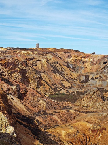
Further round from the open cast section I came across a large lake and several smaller lakes and ponds; the water in the large lake seemed to be very clear but that in the smaller lakes bore testament to the zinc-and-copper-rich landscape in which they lay. Hawthorn bushes and clumps of buttercups and other wild flowers were dotted here and there, so with much more greenery around the area it didn’t look quite as desolate as the open cast section and it was hard to believe that all this was halfway up a mountain.


From the lakes the footpath was wide and straight and with the final few photos taken I continued my downward route, eventually arriving back at the car park. Distance-wise I hadn’t really walked that far, maybe just a mile or so, but this walk wasn’t about the distance it was about what I’d seen. I had to admit that I’d been surprised and somewhat amazed by Parys Mountain; it was far from being the blot on the countryside I’d previously thought it to be and in its own way, with its unusual landscape and diverse range of colours, it was strangely beautiful. I knew I hadn’t explored as much of it as I could have done so it would certainly be one place I would return to in the future.

Linking this with Jo’s Monday Walk where she’s still in Florence – do pop over and join her for a walk round some fascinating gardens with some fabulous views.
I try to fix one thing….
And end up messing up several others.
Last night I noticed that my post about Bolton Abbey, which I’d only written that morning, had one glaring fault – the caption under one of the photos had somehow come out in a different font to all the others. Now it may very well not have been noticeable to anyone else, and if it was maybe no-one would have cared anyway, but it was noticeable to me and it was bugging me. It just looked so completely wrong that I had to do something about it, so I set about amending the post – except things weren’t quite as easy as they should have been.
In theory it should only have been a matter of deleting the wrong caption under the photo, selecting the correct font and retyping the wording, but every time I tried it either reverted back to the wrong font or separated the caption box from the photo it belonged to, and trying to join the caption box back to the photo resulted in the photo being deleted completely. After several attempts to get things right I ended up with more things wrong – the wrong font underneath two more photos, blank caption boxes all over the place and some photos deleted – and after persevering for two hours I was ready for throwing the pc through the nearest window.
Now I must admit that when I started this blog last October I didn’t particularly like the WordPress system, and I still don’t. It’s so much different to Blogger which I use for my camping blog, and I’ve found that in comparison some of the features aren’t as easy to use – and it also seems that certain errors aren’t all that easy to rectify.
So this morning I made another attempt at amending the Bolton Abbey post and yet again WordPress wasn’t playing ball so there was only one thing I could do before I lost my sanity – delete the whole post and start again from scratch. Needless to say I scrutinised everything carefully as I went along and checked it all three times before I hit ‘publish’ and this time everything is as it should be. Unfortunately though, deleting the original post has also deleted any comments that were made on it – so if you’ve read the new post and had that feeling of deja vu, or you’re wondering where your comment went, then I can only apologise for any confusion. Hopefully it won’t happen again – and if it does, don’t blame me, blame WordPress!
An autumn walk round Bolton Abbey
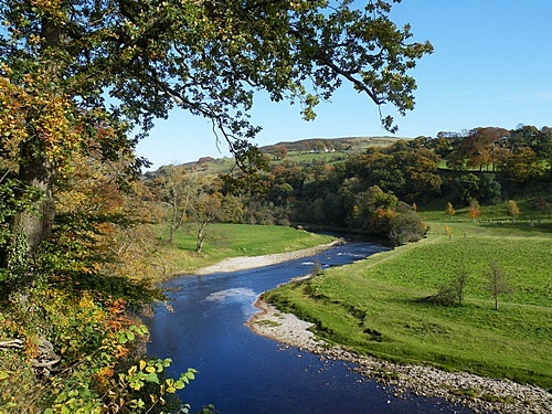
This was a walk I did on a lovely sunny autumn afternoon while camping near Skipton in North Yorkshire. While Bolton Abbey village itself is tiny the whole estate encompasses 33,000 acres of land including an ancient woodland and eight miles of the River Wharfe, and it’s owned by the Cavendish family who also own Chatsworth House in Derbyshire and Lismore Castle in Southern Ireland. There are three car parks in different parts of the estate and the fee for parking includes using any or all of them on the same day, and my walk started at the one in the village itself.
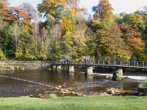
A short distance along the road from that car park a large ‘hole’ had been made in the stone wall bordering the pavement, and a wooden gate and wide steps took me down from there to a path which wound its way across open grassland towards the old priory and the river. Crossing the river by the bridge – with two dogs in tow I wasn’t brave (or daft) enough to try using the nearby stepping stones – I passed a wide sand and shingle beach and followed the contours of the land round a large horseshoe-shaped bend in the river.


Just after the bend the path disappeared into woodland and I walked for quite a distance before emerging back out at the riverside with more open grassland to my right. Up ahead was another bridge and though I could have continued on the same side of the river I decided to cross the bridge – the Pavilion Cafe was across the far side so it was an opportunity to stop for coffee and cake before continuing my walk along the other side of the river.


Close to the cafe a gate led to the start of a large well kept grass parking area which extended for quite a distance along the riverside, and across the river I could see the path I’d just walked along. Even though it was October the weather was still quite warm and as I walked through the parking area I saw a few families enjoying picnics on the grass near their cars. Leaving the parking area behind a minor path took me across open land and up an incline to the beginning of the long driveway down to the parking area, and I emerged onto the road by the Cavendish Monument.


Walking along the road from the monument I had several opportunities to take some shots overlooking the river, and looking at one particular bend reminded me of a time a few years previously when, on a day out with my partner and some friends, I’d gone sailing down that stretch on a pink inflatable armchair – it was great fun but regrettably I’d never had the opportunity to repeat it.


It wasn’t long before I came to another gate and some wide steps leading back to the riverside and the ruined priory; it was a fascinating place and I spent quite some time wandering round and taking photos. Eventually though it was time to go so I made my way round the back of the adjoining church, past Bolton Abbey Hall and its lawns and along the driveway, emerging back onto the road not far from the ‘hole’ in the stone wall, from where it was only a short distance back to the van.